Monthly Archives: August 2024

The castle – “Another good time had by all…”

*   *   *   *

Gallery image of this property
Le Château de Cambiaire, where we got to spend the night of Monday, October 2, 2023…

*   *   *   *

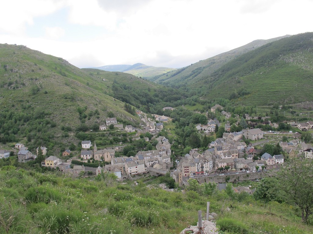
In the last post we hiked down to Saint-Germain-de-Calberte, on October 1, “What turned out to be a really eventful and awe-inspiring day.” That left only two more days hiking on the Chemin de Stevenson; first, “an easy 5.5 miles to Saint-Étienne-Vallée-Française, then another 8.1 miles to the end, Saint-Jean-du-Gard.” If all went according to plan we’d get to St. Jean on Tuesday, October 3, “145 years to the day after Stevenson ended his journey.” (Though his journey ended in Alès, some 34 miles east of St. Jean. We’d be taking a bus to Alès on October 5.)

I started that October 2 with a note back home on Facebook, with a picture: “Good morning, ‘Sunrise over the Cevennes!'” I added that we were supposed to have a short hike, and that hopefully it would be “nice and boring, smooth level path all the way.” Later I added that it was a fairly smooth hike, and that we “ended up at basically an old castle, high atop a hill in St. Etienne Vallee Francaise. Built entirely of rock. You’d think there wouldn’t be any rocks left over for the Stevenson Trail, BUT THERE WERE! And rocks o’ plenty. But seriously, a spectacular place to stay. Medieval, and definitely not your Motel 6.”

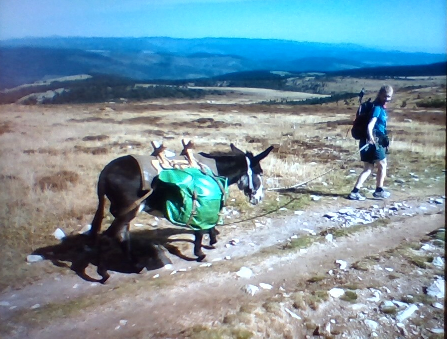
Getting there we saw more locals along the way, out hunting for the mushrooms that seem to be a favorite pastime. (Like back in my college days?) Also, strangely, we hiked through a lot of what seemed to be tropical rain forest, complete with stands of bamboo and “ferns aplenty.”

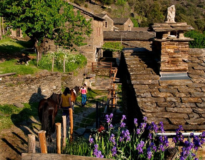
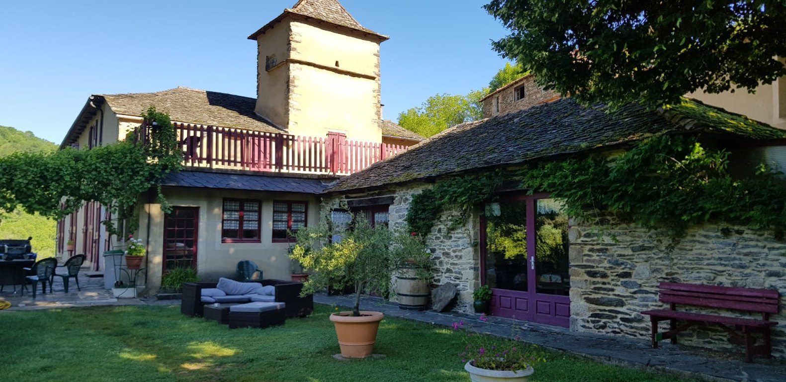
Our goal was Le Château de Cambiaire, Saint-Étienne-Vallée-Française, and you can see it from miles away. But how to get there? A river – Le Gardon de Saint Martin – runs along the main drag, “D984,” leading into town. But to get to the chateau you have to get off the main road and on to a side road, “Le Meyran,” with a turn that comes way before you get into town. From there it weaves back and forth up a steep hill to where that road splits, and there you have to get on a side-lane, “St.-Etienne Val Franc Bourg.” Then hike up another hill to the chateau

Still, we got there in good time, by 2:00 in fact, then faced a slight problem. You can’t check in until 3:00, which led to “Lots of waiting around.” Fortunately the place had a bar, in a side building, and after waiting patiently a while, sitting at an outside picnic table and being observant, I saw a man who seemed to be part of the staff coming in and out. After a bit he went in again and I followed, then managed to persuade him – with sign language and some pointing-of-fingers – to pour me a draft. From there I was happy and went on to “wax poetic.”

Sitting at a picnic table, looking out over the light-speckled green valley below, I got out my pocket notebook and started scribbling, a la Hemingway. I first noted the hike was a “milk run of sorts. Left the apartment at 10:10″ and from there a “veggie store” in  Saint-Germain at 10:21. We ended up officially checking in at the chateau at 3:35, because of a delay of sorts. Of the setting I later wrote: “Neat old place. Medieval, dark-paneled wood. The guys’ room (BR) in the turret of this old towered place.” I wrote that part of my ode to the place while “sitting with a Stevenson blonde beer, looking out over the valley, three mountains on the horizon.” Then this:

Tomorrow, last day hiking. Thoughts of home? 8.1 miles to go… What have I learned? Have I developed? I think there’s a book in this. Too! Like the other adventures. Zen moment here, “Tasting the breeze!” – Grazing horse down below. Soft Cevennes sunlight. Soft breeze. Moments like this make the plodding, plugging along for hours, sore feet and all, all worthwhile.

So much for stream of consciousness, but in time I got a little antsy. And as it turned out, dinner wasn’t until much later. (We weren’t exactly sure.) So at 6:30, needing a break, I hiked back down the hill and along the river, of which I wrote later. “Going down I heard kids. They were down by the water tossing rocks in. I could hear them way up, leaving the chateau.” A pleasant enough interlude, watching them do what I used to do as a kid, but then came some drama.

“Right by the city-enter sign, two heavy-armed gendarmes. Impressive, dark blue trousers light blue shirts. Like bad-ass Air Force dudes. I tried my hardest not to look suspicious. Like a doofy harmless American tourist? I dreaded the chilling ‘May I see your papers please?'” The thing was, they didn’t seem to have any reason to be there. Just standing around. Which brought to mind something I’d read in Travels with Charley. John Steinbeck described coming back into the US from Canada, being stopped at the border and asked, “Please step into the office.”

This request had the effect on me a Gestapo knock on the door might have. It raises panic, anger, and guilty feelings whether or not i have done wrong. My voice took on the strident tone of virtuous outrage which automatically arouses suspicion.

I certainly didn’t want that to happen. (And I had had those two beers.) But nothing happened. I made good and sure to walk up the road far enough not to look like I was turning and heading back just because I saw them. (Talk about raising suspicion.) Then made it back to the chateau, where I sat at a picnic table and started jotting again. And this: “At 6:50 p.m. the bar guy just came by. Nice guy! Very attentive! Brought a Stevenson out to my picnic table with a little Petri dish kind of thing with pretzels.” Later still I added, “I love sitting here, or in a Paris sidewalk cafe, scribbling away, like I’m Hemingway or something. Tom just came out of the room. I directed him to how to get a beer. And we reminisced.” Of old times, back when we were kids.

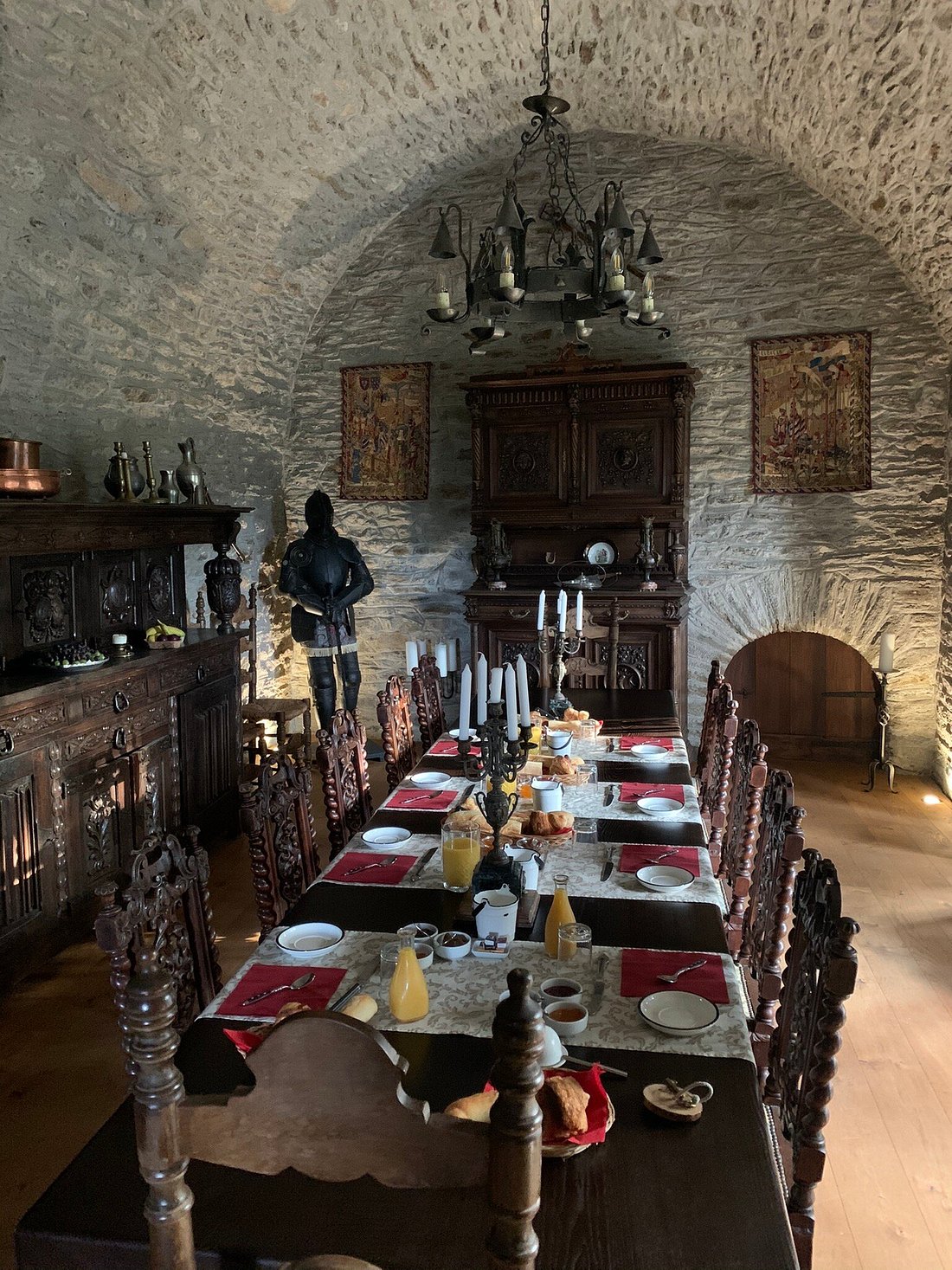
And finally, to dinner, in the ancient wall-of-stone dining room seen below. (But you know, packed with pilgrims?) Along with the usual complimentary big bottles of shared wine, a full three-course meal. For some reason I didn’t write about the first course, but the second was a “combination salad, veggie bowl, lots of rice and two local-made sausage links. (‘Erp!’) But good.” Then came the dessert, “A very rich dessert, with whipped cream and like a graham cracker crust on the bottom.” (And another good time was had by all.) Which led me to observe:

These three and four course dinners late at night are killing me! (Plus wine of course.) At home I usually don’t eat after 6:00, and then only a salad. I dread that first weigh-in Monday morning, October 9.

But all that would come later. Meanwhile, tomorrow is our last hiking day, to St. Jean du Gard. Then a day or two later we head back to Paris, where apparently they were having a plague of bed bugs. (“Oh thank you, France!”) But hopefully that’s not on our future agenda.

*   *   *   *

 “Another good time was had by all– you know, with people here?

*   *   *   *

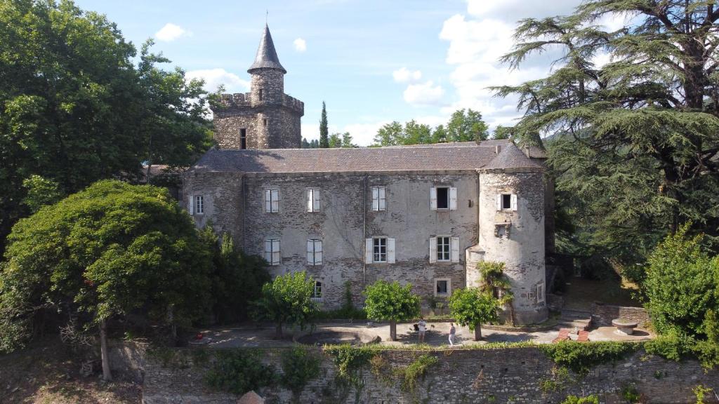
The upper image is courtesy of Le Château de Cambiaire, Saint-Étienne-Vallée-Française, our goal that October 2. And to those who might say this place did not fit the term, see Castle – Wikipedia:

castle is a type of fortified structure built during the Middle Ages predominantly by the nobility or royalty and by military orders. Scholars usually consider a castle to be the private fortified residence of a lord or noble.

Re: Milk run. According to Wikipedia it has multiple meanings, including that during World War Two especially, for United States Army Air Corps and Royal Air Force crews, a milk run was a “military air mission posing little danger.”

Re: “Tasting the breeze!” A phrase from my nephew-by-marriage, describing his son – my great-nephew – in a swing, going back and forth, eyes closed, thoroughly enjoying himself.

The Steinbeck quote is at page 86 of my Penguin Paperback version. He tried an end-run, to “creep along the neck of Ontario,” thus bypassing heavy traffic in Cleveland and Toledo.

Re: Bed bugs in Paris. See 2023 Paris bedbug infestation – Wikipedia. And apparently the city is having another this year, Bedbug panic sweeps Paris as infestations soar before 2024 Olympics. Which means this is a good year to go to Spain.

The lower image is courtesy of CHÂTEAU DE CAMBIAIRE – Prices & B&B Reviews (Tripadvisor).

*   *   *   *

From a Cottage to a Castle (and a beer)…

*   *   *   *

Our goal at the end of Sunday October 1, “ABB ‘Cottage in the Heart of the Cevennes…'”

*   *   *   *

August 19, 2024 – In the last post we made our way to St. Julien and on to Cassagnas. From there, Sunday October 1 we hiked on to Saint-Germain-de-Calberte, “what turned out to be a really eventful and awe-inspiring day.” From there we had only two more days hiking; an easy 5.5 miles to Saint-Étienne-Vallée-Française, then another 8.1 miles to Saint-Jean-du-Gard. We’d get there on Tuesday, October 3, “145 years to the day after Stevenson ended his journey.” Which means we’re coming to the end of this travelog. Or at least the hiking-with-a-pack part.

Which leads to my next major bit of note-making, that late Sunday in Saint-Germain:

Good evening from Saint-Germain-de-Calberte… We got here after hiking 11 and a half miles from Cassagnas. Interesting, eventful day, starting with a misty rainbow just setting out this morning. Early on we came across a guy riding a horse, coming the other way, with a dog and a donkey as well. “That’s one way to do the Trail.” Then passed a passle of sheep, 60 to 70 I’d say, coming through. (We let them pass. Carol took a video.) Four sheep dogs herding them, two in front, two behind. And two or three shepherds. Quite a sight. Then got to the top of “Col de la Pierre Plantée,” at least that’s what the Stevenson pamphlet called it.

Col de la Pierre – the Wikipédia article is all in French – is not as high as Mont Lozere or “Signal,” but had more spectacular views. To see those views we started the morning in fog, looking west through trees and bushes to distant hills topped by a rainbow arc. Then more toward the east on a slightly rocky trail – but doable – the sun peeked in rays through another line of trees.

Approaching the summit we saw a scenic outcrop. The area teemed with more stacked-on-rocks, what appeared to be ancient stone altars of the kind we’d seen before on hilltops, but curving serpentine at this place. Then we saw a “little bitty speck to the right of the small tree ‘down there.’” It turned out to be an adventurous hiker who had clambered out onto the outcrop. We decided to join the fun, and from there a picture-taking party developed.

More hikers came along, saw what we were doing and they decided to join the fun. (Including a French couple hiking with a big white dog with a spotted back.) We all took turns clambering out onto the precipitous outcrop. (Climbing “awkwardly or with effort especially by using both the hands and the feet.”) We’d taken off our packs but still took care to tread carefully. Then took pictures of ourselves and each other, and “a good time was had by all.” Lots of back-and-forth French-to-English and back again. Then for us it was back on the trail again.

Shortly after that we stopped to enjoy some of the picnic lunch prepared for us by the nice lady at last night’s lodging. Like most days, today there was no place to stop and refresh. Most towns we’ve passed through were “dead dog,” almost ghost towns. “How about a stinkin’ 7-11, some place to get a cold drink?” But this salad was pretty good. Garbanzos, edemame, lima beans, various veggie bits, tasty dressing.

From there the trail continued part smooth and part rocky. “Except at the end of the day, always a REALLY rock-infested stretch heading into the destination town. Like this afternoon.” And it did seem that way, both then and in hindsight. No matter how smooth the Chemin may have been most of the day, as the afternoons wore on the trail magically grew more and more rocks. Maybe it was just because we got more and more tired as the day wore on. Or maybe it happened because the hike took longer than expected? As I wrote later, “Carol’s Fitbit said we did 11.5 miles, up from the projected ‘9.3.’” I added that overall it was a pretty smooth hike, “trailwise. Except for that last part – always – when coming into your stop-town. Never fails.”

Which leads again to the question, “Why would anyone in his right mind put himself through such agony, especially at age 72?” I’ll get to that in a bit, but despite the end-of-day magic-trail-rocks, we eventually found the place, Cottage In The Heart Of The Cevennes. (Check out Google Maps to see lots of zig-zag back-and-forths on the last part of the hike in from Cassagnas down to Rue de la Cantarelle in St. Germaine-de-Calberte.) Then it took a while to figure out where “in town” it was exactly, but eventually, “there it stood, on a hill overlooking a deep valley, with azure mountains in the distance, some of which we’ll have to climb in the next two days.”

Now back to the question, “Why would anyone put himself through such agony?” That evening, relaxing on the slat-shaded balcony, beer in hand, looking south over the azure mountains we ourselves would clamber over in a day or two, I pondered the question. Part of the answer comes from the feeling you get at the beginning of each day. I remembered a Zen saying from years before. “A child looks at a mountain and sees a mountain. An adult looks at a mountain and sees many things. A Zen master looks at a mountain – and sees a mountain.” Except that when you’re an adult on a Camino hike – and “in the proper frame of mind” – you don’t just see a mountain. You see that of course, and for the moment just that, but you also have a lifetime of memories to “mule over.*” More than that, each morning you are a child again. Everything is fresh, new and exciting, and each bend in the trail reveals things you’ve never seen before.

But of course, the warm bed, hot shower and cold beer at the end of a day helps a lot too.

So much for my meditations that Sunday evening. Which leads to another note I made: “Tomorrow, a nice easy 5.5 mile walk, then Tuesday we reach St. Jean du Gard, where our hike ends. 145 years to the day from when Stevenson arrived there.” Aside from that:

(Monday night we got to stay in a castle!)

*   *   *   *

Gallery image of this property

*   *   *   *

The upper image is courtesy of Cottage In The Heart Of The Cevennes Saint-germain-de-calberte France – Image Results.

For this post I borrowed from the September 10, 2023 post, An update – Stevenson Trail “REST of the Way.” (Which I actually posted on the evening of September 9. I flew out of Atlanta to Paris on September 10.) That post noted that “Stevenson reached the town [St. Jean du Gard] on October 3, 1878.” However, it seems he actually ended his journey in Alès, not St. Jean. We rested on October 4, in St. Jean, then took a bus to Ales on the 5th, and from there a train to Paris on the 6th, as detailed later.

Note: We figured the October 1 hike to St. Germaine would cover 9.3 miles.

Note that Wikipedia spells Travelogue with an extra “ue,” which article directs you to Travel literature – Wikipedia. That term “encompasses outdoor literatureguide booksnature writing, and travel memoirs.” The section “Composition of a Travel Journal” indicates there is no specific format, but such journals typically include “details and reflections about an individual’s experiences, observations, and emotions during the journey.” They also include notes on the activities engaged in sites visited, “interactions with the local culture, such as trying traditional foods, festivals etc.,” personal reflections – “thoughts, feelings, and impressions” – along with memorable moments. “These could be positive experiences, surprises, or even unexpected challenges throughout the journey.” (Like those “gang aft aglay” moments?) I’ll be reviewing that article…

Re: “Mule it over.” A quote from John Steinbeck’s Travels with Charley, noted at Reader Q&A – Goodreads, about his knowing “from thirty years of my profession that I cannot write hot on an event. It has to ferment. I must do what a friend calls “mule it over” for a time before it goes down.” See also Mull It Over: Definition, Meaning and Origin.

The lower image is courtesy of Le Château de Cambiaire, Saint-Étienne-Vallée-Française, our goal on Monday October 2. And to those who might say this place did not fit the term, see Castle – Wikipedia:

castle is a type of fortified structure built during the Middle Ages predominantly by the nobility or royalty and by military orders. Scholars usually consider a castle to be the private fortified residence of a lord or noble.

*   *   *   *

Down to St. Julien – on to Cassagnes?

*   *   *   *

A look back at Pont-de-Montvert, heading up and “cross country” to Saint-Julien-d’Arpaon

*   *   *   *

August 13, 2024 – The last post ended with us leaving Pont-de-Montvert – after our second (and last) day off before finishing – and heading to down to Saint-Julien-d’Arpaon. The post also noted that a hike on today’s GR 70 is way different than the one Stevenson did. No real outdoor camping and no donkey to care for. And today there really is a trail to follow, but most of Stevenson‘s hike was “cross-country.” Picking his way through thick forests, up and down mountains, with nothing to guide him but a compass that sometimes worked and sometimes didn’t.

But strangely enough, the day we [left] Monvert we were about to get a glimpse of the same kind of hike Stevenson went through… [O]ne challenge Tom faced on our day off was trying to figure out how “to bypass that big-ass Florac loop, and short-cut down to St. Julien. (South of Montvert the Trail cuts way west to Florac, then cuts back way east down to St. Julien, with the net effect that you have to “pay for the same real estate twice.”)

To cut to the chase, that day’s hike was harder even than the one up and over – and especially down from – Mont Lozere, and that’s saying something. But the photo above gives a bit of foretaste, a view of Pont du Montvert that we saw starting the day. Getting up to that point we averaged a bit over one mile an hour, and it didn’t get much better as the day progressed.

One bad thing about Montvert (“Greenhill Bridge”) – and even though it was “a beautiful little town” for a day off – was no WiFi. So I had to wait until we got to St. Julien (finally) to report that our wonderful day off “was sandwiched in between two humongous mountain climbs. Mont Lozere on Wednesday, and yesterday, Friday, 13.68 miles up and over ‘Signal du Bouges.'” And add that Friday’s hike “was tougher, it seemed to me,” and that’s saying something.

In fact, it was so tough that I didn’t write much about it when we got to our place for the night. Three lines in my journal: “Long day. Tough day. 13.68 miles, over ‘Signal du Bouges,'” then down our Florac bypass to St. Julien d’Arpaon. “Dragging tail into the the CG place.” The “CG place” turned out to be a kind of campground, Les Copains à Bord (Chambres-d’hotes), “Nestled in the heart of the village of Saint-Julien-d’Arpaon.” (Which in 2019 had a population of 93.) But looking back I can’t help but wonder why I didn’t write more about that “bypass.”

I’ll get back to the lodging later, which was quite pleasant as I recall. But why no notes later in the evening? Part of it was the distance, but not much longer than 12 miles up and over Mont Lozere. Part of it was no establishments to stop and refresh between Pont de Montvert and St. Julien. And part of it was that going “cross country,” off the beaten and established path, short-cutting it through thick forest and around big boulders and rocky path. (More than usual?)

To set the stage, Signal du Bouges is five miles out from Pont de Montvert and another 2.8 windy (as in “winding”) miles over to Mijavols. And somewhere west of of Mijavols we cut down through the deep woods, heading straight south (more or less) to St. Julien. And while I didn’t take many notes about the short-cut I did take pictures. Of reaching the top of Signal du Bouges, first through tussocks of clumped bush and up to forest clearings at the summit, strangely populated with numberless towers of piled-on flat rocks. (Where as I recall we had a packed-ahead lunch of sandwiches, apples and by-now-lukewarm water.)

But the next photos show smooth path, with distant mountains visible in the late afternoon haze, not hordes of trees crowding over you and big boulders blocking your way. I can only imagine that any stops in that cross-forest hike were few and far between, and that in such stops I was too bushed to haul out my tablet and take a picture. But we made it, finally, doing the last mile or so on the paved N106 highway. And I was never so glad to see pavement…

Les Copains à Bord is a campground in the sense that it’s rustic and stone-walled, with picnic tables, outdoor lounging tables and a spread-out lawn with “south-facing terrace.” The doors to the rooms all open to the outside (“independent entrance”), and to get to the communal dinner you head out and down to the main building. I took pictures of the meal, first a strange-looking but delicious cold pizza topped by a dollop of heavy cheese, and a main course of vegetable lasagna. (As I recall they had beer too.) Our lodging was a “cozy” one-bedroom cottage.

So that was Friday, September 29, but what happened on Saturday the 30th? I have some strange notes from that day, with our destination as LE MIMENTOIS – B&B in Cassagnas. (Not “Cassagnes,” with an “es” at the end. That similar-named town is 30 miles and over 11 hours hiking off to the west-southwest of St. Julien, so the answer to the question in the title is a definite “NO.”) Anyway, the Le Puy guidebook said it should have been a short, easy 4.8-mile hike, and Google Maps had it as a 5.7 mile hike on a different route. But as I wrote later, “Five mile hike turned into six. A bit more confusion finding this place, but turned out well. 2 beers after early shower. Mostly nice smooth hike along an Alpine-like river. [The “River Mimente.”] Until we got to what I thought was Cassagnes.” But I didn’t explain the confusion in my notes.

Some things I did note: Number One and as noted, it was supposed to be an easy day but wasn’t, in part because of my “frustration at not knowing what was what.” (Apparently in terms of “where the hell are we?”) Another thing? On the way I toyed with the idea of getting a new phone system myself, one where I could track where we were and where we were heading, instead of having to always trust Tom and Carol. (But I got over that, mostly, with some tweaks after getting back home.) On the plus side? “There’s beer here. I’ve had two, outdoors, as of 4:38 p.m. Turned out to be a nice afternoon.” That was in my pocket notebook, the one I carried in the “It’s European” thing that only looks like a purse.

Then there’s what I wrote in my official 2023 day planner, the one I stashed in my pack:

Saturday night, 9/30. Tonight we sleep. One big bedroom, 5 beds. Carol has taken one mattress and put it in the big shower room. The light is to my right & behind me thus the funny writing 2 small beers about 4:00 p.m. – Wine at dinner. Best dinner yet? Vichyssoise soup veggies chicken drumsticks + salad fromage and some almondine dessert. Very pleasant. Best dinner yet?

Looking back on my handwriting I’d say I had a pretty good time, and that the day turned out well after all. Another case of “ordeal and triumph,” which seems to happen a lot on a Camino hike. Or maybe “sin and redemption?” But as always on such hikes, “tomorrow is another day.”

And next up? On October 1 we hike on to Saint-Germain-de-Calberte, in what turned out to be a really eventful and awe-inspiring day. (“No really!”) Also next up? An anecdote or two for those who may by now be concerned about my occasional overindulging on the Camino. (Short take: “You work it off!”) In the meantime, here’s a look at one place we stayed. Stay tuned…

*   *   *   *

 Les Copains à Bord, the “almost campground” we stayed at Friday, September 29…

*   *   *   *

The upper image is courtesy of GR-70 Up From Pont De Montvert – Image Results.

The Wikipedia article on Cassagnas said the village “lies in the valley of the River Mimente.” Also:

Stevenson mentions the village… “I was now drawing near to Cassagnas, a cluster of black roofs upon the hillside, in this wild valley, among chestnut gardens, and looked upon in the clear air by many rocky peaks. The road along the Mimente is yet new, nor have the mountaineers recovered their surprise when the first cart arrived at Cassagnas

Some notes about the “heavenly” meal on Friday the 29th in St. Julien. Vichyssoise is a soup “made of cooked and puréed leeks, potatoes, onions and cream. It is served chilled and garnished with chopped chives.” In French cooking, “almondine” is a cooking technique that “involves incorporating almonds into a dish to enhance its flavor and presentation. Typically, this method involves toasting or sautéing almonds and then using them as a topping or garnish for various dishes.”

The lower image is courtesy of the Les Copains à Bord website, on the place in St. Julien.

And as always, you can see good information and photos at the site, Walking the GR70 Chemin de Stevenson – I Love Walking In France. 

*   *   *   *

Our second day off – and reflecting…

*   *   *   *

Customers relax over a cold drink at a Café in Le Pont-de-Montvert
Enjoy a cup of coffee “or a cold drink” at Cafe Le Commerce in Le Pont-de-Montvert

*   *   *   *

The last post saw we three hikers – me, brother Tom and his wife Carol – finally getting up and over Mont Lozère and on to Le Pont-de-Montvert. (French for “Greenhill Bridge.”)

There we took our blessed second – and last – day off, before reaching the end of our hike at St. Jean du Gard. As for the hike “up and over,” the top of Mont Lozere offered some stunning vistas. Up there the summit was flat as a table – wide open and normally “exposed to fierce sunshine and biting winds” – and also filled with tall pillars of rocks. (But no bushes or trees – and no animal life either.) On the plus side, the winds that day weren’t actually that bad. In fact it was so pleasant up there that we “dawdled at the summit.”

The hike down from that mountaintop experience was another story. As I wrote later, “The longest day so far, 10 hours on the Trail, a full 12 miles. Some bad-ass rocky paths, especially near the end when you’re good and tired.” But we finally made it up and over Mont Lozere, then down to Montvert, sore feet, sore back and all. Put another way, “After 10 hours on the Trail each rocky foot-step hurt like hell. Back hurt, feet hurt, not fun.” But after a hot shower, fresh clothes and three beers (with salad), “things looked better.” Or as I put it next day (the late afternoon of our day off), and after lunch at Cafe Le Commerce again, shown at the top of the page:

Yesterday at the end of the hike down from Lozere I was cussing up a storm, mentally. But now, at the end of a long, sweet day off from hiking, relaxed, well fed, two beers for lunch, my hiking companions upstairs, napping, not so bad.

But I’m getting ahead of myself. After “dragging tail” into town, showering and freshening up, we went looking for a quick and good meal. We found it at the Cafe right across the mid-town bridge from our apartment in the Quartier de la Moline shown on Google Maps. (Our spreadsheet called the place La Maison de Voyageurs, but it doesn’t seem to have a website. But you can glimpse it among the row of buildings peeking through the trees in that top photo.)

The main part of the apartment had two floors and two bedrooms, both upstairs. So far on the hike we’d been taking turns getting the good rooms, and now it was my turn to get the “bedroom” downstairs. (A pullout couch in the kitchen area. Carol got the master room with the big bed and Tom got the room with bunk beds.) Unfortunately the bathroom was also upstairs, which made for some agony later on, waiting for it to “open up for business.” (Par for the course for a guy who likes his beer as much as I do. Plus three “older folk?”) To get upstairs you had to climb some narrow squeeky-squawky stairs. The place also had a washer and dryer – and getting a dryer at your lodging is rare on a Camino – but they were in the basement. To get to it you had to go outside, into the street and then down through a separate locked door.

But the fresh-clean clothes made a big difference, as did a saunter through town next morning, The Tarn (river) cuts right through the middle of town, over many a rock and boulder:

Protected on both sides by steep ridges, Le Pont-de-Montvert straddles the banks of the River Tarn as it meanders along the valley floor. The village is one of the prettiest towns along the GR70 Chemin de Stevenson, and is the perfect spot to spend a lazy afternoon relaxing in a café near the river.

We followed that leisurely stroll with lunch at the same cafe we had dinner the night before. (I had the plat du jour and two beers.) Later that afternoon I figured to “yoga my ass off” (as Tom put it), to loosen up sore muscles. Plus I could look forward “to Carol’s touch-of-home spaghetti tonight for dinner.” As for the weather, it stayed chilly, as it had been most of the trip.

I’ve been cold most of the day. It was warm outside, for lunch in the sun, but inside, windows closed it’s cool, very cool, especially since my white sweatshirt is in the wash. At 5:00 p.m. [I wrote later] the day of rest stretches on. My feet are icy but I’ve done some good indoor exercises, yoga, ab crunches and such. Read some, wrote some.

To explain that 5:00 p.m. “icy feet,” we actually did two loads of laundry, which was quite a luxury. I saved the white sweatshirt for the second, afternoon load. But even though my feet were cold I could still snuggle under some covers and do some reflecting. Some written notes:

Impressions? Not like Stevenson’s trip, thank God. (No camping per se.) Some smooth trail but way too much rocky stuff. Twist and bend, achy feet, loss of balance. The hiking staff I found on the trail helps a lot, especially those rocky places and/or going downhill, feet jammed up into the toes of your shoes. So what am I discovering? Hiking with a pack, heavy, in a foreign land? Not being able to converse (easily) with the locals? Being cut off from normal everyday conversation. Learning to deal with unfamiliar, trying circumstances. A new bed every night. A new shower configuration too. Moments of pure beauty and bliss? Hours of walking, often on hostile paths, but at the end a feeling of accomplishment. And looking ahead to new challenges, “Tomorrow, And Tomorrow, And Tomorrow.”

A lot of that sounded like complaining, but maybe it was more venting, expressing negative emotions “such as anger, frustration, etc.” And maybe it was cathartic, “involving the release of strong emotions,” as through writing them out? But let’s start with the top of the list.

A hike on the GR 70 today is way different than what Stevenson went through. No camping outdoors, no donkey to poke and prod, not to mention feed and care for. For another thing there really is a trail for modern hikers, but that wasn’t at all true in 1878. For  RLS most of the trip was hiking “cross-country,” picking his way through thick forests, up and down mountains, with nothing to guide him but his compass, and even that was subject to anomalies. (Like the part where he ran across the “impudent sly sluts,” when his compass didn’t work, he couldn’t find a place to stay and had to set up camp late at night, in the dark and in the wind, rain and hail.)

But strangely enough, the day we were to leave Monvert we were about to get a glimpse of the same kind of hike Stevenson went through. As noted in the last post, one challenge Tom faced on our day off was trying to figure out how “to bypass that big-ass Florac loop, and short-cut down to St. Julien.” (South of Montvert the Trail cuts way west to Florac, then cuts back way east down to St. Julien, with the net effect that you have to “pay for the same real estate twice.”)

How that turned out is a story for next time. Meanwhile – and a bit of foretaste – here’s a view of Pont du Montvert, like what we saw looking back down on our Friday-morning climb. Getting up that high we averaged 1.2 hiking miles per hour. And that was just the start of our day…

*   *   *   *

That’s Le Pont de Montvert, WAY down there…

*   *   *   *

The upper image is courtesy of Walking the GR70 Chemin de Stevenson – I Love Walking In France. The caption is from the website itself, along with this: “Le Pont-de-Montvert is one of the prettiest towns along the Chemin de Stevenson and the perfect spot for a lazy afternoon relaxing in a café near the river.” (A side note: The website has lots of good pictures of sites along the GR-70.)

According to French-English dictionary | English translation | Reverso, the term quartier translates to “district” or “area.” On Google Maps the term is abbreviated “Qur.”

Re “Tomorrow, And Tomorrow, And Tomorrow.” One site said this speech by Macbeth signifies how your days stretch out, “each one the same as the one before … tediously, until the end of history.” And the individual – a poor actor or “walking shadow” – simply goes through the motions of life, “and then bows out [from] a story told by an idiot, full of noise and passion, but meaningless.” (Macbeth Soliloquy.) But I was using the phrase in an ironic sense, “the expression of one’s meaning by using language that normally signifies the opposite, typically for humorous or emphatic effect.”

Re: “Pay for the same real estate twice.” As noted in Leaving Cheylard, on to St. Etienne, that referred to General Patton’s not wanting to “to fall back and regroup” during the Battle of the Bulge. See Not me. I don’t like to pay for the same real estate twice.

As to my sentiments about taking a shortcut to bypass the Florac loop, compared to the hike down from Mont Lozere,, I said “I hope it doesn’t involve more rocky [bleep]ing trails. I’ve had more than enough of those yesterday, sore-footing it into Pont de Montvert.” (And I included the “[bleep]” in the original, since this is a family-value blog.)

The lower image is courtesy of GR-70 Up From Pont De Montvert – Image Results.

*   *   *   *

Over Mont Lozere – and on to “Greenhill Bridge…”

*   *   *   *

Hiking up Mont Lozere, we saw this fellow pilgrim really following in Stevenson’s footsteps…

*   *   *   *

To get up to date, “last Wednesday” (September 27, 2023), we three hikers – myself, brother Tom and his wife Carol – left Hôtel Restaurant La Remise, in Le Bleymard. That day we faced a 12-mile hike to Le Pont-de-Montvert. (French for “Greenhill Bridge.”) The challenge that day was climbing up and over Mont Lozère. (A “massif 5,574 ft above sea level … within the Cévennes National Park,” and what that guidebook from Le Puy called Sommet de Finiels.)

That hike was so challenging I had to split in two separate posts. That is, the last post noted Mont Lozere was the highest point on the GR 70, “a popular long-distance path following approximately the route” Stevenson traveled, not to mention “quite a hike.” And it was. But one of the fun parts was seeing “this lady and her donkey, a modern day version of Modestine, in the manner of the original R.L. Stevenson hike.” And also making it to what seemed like The Top of the World, even though there were “no trees, no vegetation” but awesome views. (Another nice event was stopping for a beer on the way up, but I’ll talk about that later.)

So anyway, Stevenson reached the summit the morning of Sunday 29 September, 1878, “having spent the previous night camped in the woods beyond Le Bleymard.” From the top of Lozere he saw “the hazy air of heaven,” and looking down “a land of intricate blue hills beneath his feet… These were the Cévennes of the Cévennes.” Today’s version of his hike follows “a draille (drove road) across the mountain, marked by montjoies (standing stones).”

As for us, we followed the drove road and saw lots of those standing-stone mounds, but for another take on the climb see Walking the GR70 Chemin de Stevenson … Walking In France:

As the path approaches Mont-Lozère and climbs Col de Finiels (the highest point on the walk), the vegetation – and the livestock – disappears… [T]all rock pillars mounted along the edge of the trail guide travelers [but] during the walking season, the path is open and exposed to fierce sunshine and biting winds.

The winds weren’t too bad that day, but at this point it occurs to me that so far I haven’t said much on how it actually feels on those long hours hiking. Especially a long hike to “the highest point on the walk.” How you pass the time? Mostly you do a lot of thinking, and remembering, mostly because there isn’t much else to do. You can admire the scenery, and in the Cevennes it was pretty awesome, but after a while that gets to be old hat. Plus a lot of time, going up or down those steep rocky trails that seem so much a part of “The Trail,” you focus mostly on not taking a wrong step, twisting an ankle or a knee. (Or “slip and fall;” a bit of foreshadowing.)

There is one relative constant. Most places you see and hear a lot of dogs, usually approaching or leaving a town or city. (Though not so much climbing Mont Lozere.) And each time I think to myself, “Roof, roof… ‘Ya think I shoulda said maybe DiMaggio?'” It’s from a really old joke:

Back in the 1930’s a man takes his dog to a talent agent on Madison Avenue. “You won’t believe it, but my dog can talk!” The agent is skeptical, so the man says, “Watch this. Rover, what’s that on top of a house?” The dog responds: “Roof, roof!” The agent is unimpressed and rolls his eyes. The man sees that and says, “No really, listen to his. Rover, how does sandpaper feel?” The dog replies, “Ruff, ruff!” The agent moves around his desk and tells the man to leave. The man asks for one last chance and says, “Rover, who is the greatest baseball player of our age?” The dog enthusiastically responds, “Roof, roof!” The man tells the agent, “Did you hear that? He says Babe Ruth is the greatest player of our age!” The agent grabs man and dog and throws them bodily out of his office. Out in the hall Rover sits up, dusts himself off and asks the man, in a thick Bronx accent. “Do you think I shoulda said maybe DiMaggio?”

It happens every time on the Camino when I hear a dog bark. I think, “Roof, roof,” and then, “Maybe I shoulda said DiMaggio?” And every time I chuckle, just like I did writing this out.

But back to the GR-70: We started out on a paved road, then onto a hard-packed and pretty smooth dirt road. As usual this hike the mornings were fresh and clean, with deep shadows alternating with bright sunlight. This day started with rolling hills off in the distance, framed by barbed-wire fences and tall wheat grass. Early on we met up with three older-lady hikers, and stopped to chat when we heard them speak English. Then a pine forest where the path turned a bit more rocky, and every so often a car would pass by, heading up the mountain. Further on fewer and fewer trees and the path got narrower. Actually the climb up wasn’t too bad.

One nice thing about that hike up: There’s a place called Station du Mont Lozère on the way, a mere 3.2 miles out of Bleymard. (And about five and a half miles from Finiels, “a hamlet on the slopes of Mont Lozère,” past the summit.) The Station is best known as a winter ski resort, but this day in late September I knew it was the only place to get a beer until day’s end. So even though it was only 11:00 a.m. when we got there, I ordered a beer. (Contrary to my general rule not to have a beer before noon; this day there were “exigent circumstances.”)

One thing I remember “even to this day” about reaching the summit – finally – was how table-smooth it was, and full of rock circles and stone mounds. Another thing I remember was the cluster of signs showing distances to various parts of the hike. One said Le Monistaire, back where we started our second day’s hike, was 135 km (83.88 miles) away. Another said St.Jean du Gard was 95 km (59 miles) away, and that’s where we were to end our hike. (And according to our schedule we would get there on October 3, 144 years to the day after Stevenson got there.) Yet another sign said Pont du Montvert was still 11.2 km (6.95 miles) away. (Meaning “that’s how far we still have left to hike, after climbing UP and over Mont Lozere!?!”)

So all in all, reaching the top of Sommet de Finiels (another name for Mont Lozere) was a true mountaintop experience. And speaking of “What do you do after [such] a ‘mountaintop’ experience,” our goal at the end of the day was still Le Pont-de-Montvert. (French for “Greenhill Bridge.’ That and the usual end-of-day warm bed, hot shower and cold beer.) And looking ahead – as I did back at home – I saw that Montvert stands “at the base of the south-facing slopes of Mont Lozère” and features “the stony granite-built traditional aspect of its closely built centre,” which is where we’d end up at day’s end. I’d also read this in pre-trip research:

The village is named for its hump-backed bridge (en dos d’âne) that spans in a single arch the swift-flowing Tarn – here near its source. The bridge is guarded by a defensive tower at the village end, now with a more amiable function: village clock. Medieval in aspect, bridge and tower date to the 17th century.

It sounded lovely, and on top of that we would end our six straight days of hiking with our second – and last – day off before the trip ended in St. Jean du Gard. But to get that blessed second day off we had to climb “all the way back down” from Mont Lozere.

That turned out to make it a long and challenging day. So long and challenging that I didn’t make any notes until the day after, during that second day of rest. One thing I wrote, on the hike over Mont Lozere: “The longest day so far, 10 hours on the Trail, a full 12 miles. Some bad-ass rocky paths, especially near the end when you’re good and tired.” I also wrote about the great view at the summit, “not too windy, but at the end of the day, after 10 hours on the Trail, each rocky foot-step hurt like hell. Back hurt, feet hurt, not fun.” But as usual on a Camino hike, after the hot shower, fresh clothes “and three beers, with salad, things looked better.”

“Tomorrow” – Thursday September 28 – we would thoroughly enjoy our second day off, but I’ll write about that in the next post. That and the challenge of Tom trying to figure out a way “to bypass that big-ass Florac loop, and short-cut down to St. Julien.” I added, “I hope it doesn’t involve more rocky [bleep]ing trails. I’ve had more than enough of those yesterday, sore-footing it into Pont de Montvert.” (I wrote the “[bleep]” in the original.)

*   *   *   *

A view from the summit of Mont Lozere, like “the Top of the World…”

*   *   *   *

The upper and lower images are both my photos.

Re: The “Roof” joke. See Moral of a silly old joke … A guy has a talking dog. He brings it to a… – Unijokes.com, or Roof! Rough! Ruth! – Justin Li. Or search “joke talking dog roof dimaggio.”

The link to Station de ski du Mont Lozère | Station à 1702 mètres emphasizes it as a ski resort. When we were there I noted mostly the good restaurant and cold beer.

Re: Finiels. See Wikipedia., which added that it “has a small number of inhabitants… The nearest village with convenience shopping is Le Pont-de-Montvert, roughly 6 kilometres (3.7 mi) to the south.”

Re: “My general rule.” I came up with that rule on 2017’s hike on the Camino Frances. On the last 10 days we switched from hiking to mountain bikes. One day I had a beer for an early lunch, before noon, and later that afternoon “my bike ran me into a ditch!” See “Hola! Buen Camino!” – Revisited:

We were zooming downhill one afternoon. I tried to adjust my left pantleg, and the next thing I knew I was laying in a ditch, bleeding like a stuck pig. And not just any ditch. A nice deep ditch covered with thorns and brambles on the sides and bottom. The “stuck pig” part came when my Ray-Bans gashed the bridge of my nose, causing it to bleed profusely…

Actually that was merely the second of three major biking mishaps in 2017.

*   *   *   *