Monthly Archives: July 2024

From Chasserades to “climbing Mont Lozere…”

*   *   *   *

A scenic view along the Robert Louis Stevenson Trail from Chasserades to Le Bleymard…

*   *   *   *

The last post saw we three hikers make it from La Bastide-Puylaurent down to another camp-in-cabins place called Le Sous Bois De Jade. (Despite some confusion in and around the little town of Chasseradès.) Estimates of the distance we should have hiked ranged from 5.1 to 6.9 up to 7.64 miles. We ended up clocking in at 8.2 miles, “mostly because we wandered around town a bit, asking for directions.” But we got some help from a nice “young” couple in town.

(Young meaning about our age group, 72 to 78.) 

Our next goal was Hôtel Restaurant La Remise in Le Bleymard. (“And beyond.”) Bleymard is where “Stevenson ate in the village on the evening of 28 September 1878 before camping nearby.” For us there was another confusion about mileage. The initial estimate was 11.2 miles, but Google Maps put the distance from Chasserades at 8.2 miles. The Le Puy guidebook put it at 10.56 miles, passing through L’Estampe and Les Alpiers. But here’s what I wrote that night: “Today we made Bleymard, from Chasserades. A mere nine miles but it felt like more. Slow going in the morning… Like 1.3 miles an hour at first, but we picked up speed later in the day…”

And finally, just in time for Mont Lozere tomorrow. [I found a hiking staff] on the Trail today. Hiking poles are a pain to carry, and to get past TSA [at the airport] but they come in handy sometimes, say, hiking up a steep mountain with lots of slippery rocks. “The Camino provides.” Or the Chemin Stevenson, whatever. Good night, from Bleymard…

“Which is being interpreted:” I generally try not to use a hiking pole, though sometimes they come in handy. On both this hike and the Way of St. Francis in 2022 I found a nice five-foot staff just lying along the trail. And for this trip, just in time for the steep rocky paths I was about to face on Mont Lozere. But then there was that incident in Rome at the end of the 2022 hike.

We’d been out in the wilds, away from all mankind, when all of a sudden we were packed in on crowded middle-of-Rome city sidewalks. I still had that long staff, plus Tom asked me to carry the fancy-schmancy pole he’d managed to sneak past TSA on the flight to Rome. (So he could check his bearings with his phone.) I didn’t want to carry two poles, so I stuck Tom’s through my pack-straps, down around my lower back. Unfortunately that left the pointy end sticking out, as we stood at an intersection waiting for the green hand to cross. Somehow the pointy end of that hiking pole stuck a bystander-local pretty good, and he let loose a string of epithets including a number of good American f-bombs. I was impressed with his language skills but got the hell across that intersection and away from him fast. Not an experience I want to repeat.

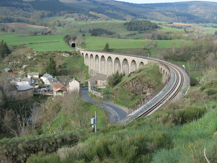
Anyway, aside from slow going and finding a hiking staff on the trail, the day’s hike to Bleymard was routine. There was that scenic view, of a rail track built on top of an old Roman aqueduct, shown at the top of the page. On that section we had to hike down the trail, then underneath the high track and through the bitty cluster of buildings, then on to and over that long ridge – that “steep mountain” – off in the distance. (Which was but a foretaste…)

We were settling into a routine, and that September 26 hike to Bleymard marked the fifth of those six straight days of hiking. (Where usually we try to take a day off after four days’ hiking.) The next day, September 27, we faced a 12 mile hike to Le Pont-de-Montvert. (The town of “Greenhill Bridge,” to which Tom’s itinerary added “Sud Mont Lozere.”) We were scheduled to stay two nights at “Le Maison de Voyageurs.” In other words, a second day off from hiking.

But first we had to hike up and over Mont Lozère, “a massif 5,574 ft above sea level … within the Cévennes National Park.” (What the guidebook from Le Puy called Sommet de Finiels.)

We had a wonderful second day off in Montvert but there was no Wi-Fi. (As Wikipedia spells it.) So I had to wait until we got to the one-bedroom cottage in Saint-Julien-d’Arpaon to post this:

A report from St. Julian d’Arpaon, in the Cevennes… Pont de Montvert (“Greenhill Bridge”) is a beautiful little town where we took a day of rest Thursday. But no Wi-Fi. It was sandwiched in between two humongous mountain climbs. Mont Lozere on Wednesday, and yesterday, Friday, 13.68 miles up and over “Signal du Bougès.” If I got the spelling right. Yesterday was tougher, it seemed to me. Dragging tail into this place.

To clarify, we hiked to Bleymard on Tuesday, September 26. On Wednesday the 27th we hiked up and over Mont Lozere to Pont-de-Montvert. (And a rugged climb it was.) There we took a second day off from hiking on Thursday, the 28th, and on Friday the 29th we left Montvert for St. Julein, which involved another steep climb, up and over the slightly lower Signal du Bourges.

I’ll talk about the wonderful second day off from hiking in the next post, but for now, “On to Mont Lozere!” As for Stevenson, he reached the summit “the morning of Sunday 29 September, 1878, having spent the previous night camped in the woods beyond Le Bleymard.” He told of a view like “the hazy air of heaven,” and from there looking down he could see “a land of intricate blue hills beneath his feet… These were the Cévennes of the Cévennes.” He also wrote that on a clear day you could see the Mediterranean, but for us the horizon was a bit hazy.

Another site said Mont Lozere was the highest point on the GR 70 and “a popular long-distance path following approximately the route” traveled by Stevenson in 1878. Also, the GR-70 follows “a draille (drove road) across the mountain, marked by montjoies (standing stones).”

And it was quite a hike. So much so that I’ll have to save that for the next post as well. For that next post I’ll have a picture of us finally reaching the top of Mont Lozere, and on the way seeing “this lady and her donkey, a modern day version of Modestine, in the manner of the original R.L. Stevenson hike.” Also about us seeing – atop Mont Lozere – “no trees, no vegetation, like being on top of the world. Awesome views, but to see them you hike all the way up, then all the way back down.” (I figured there was a lesson there somewhere.)

And speaking of the view atop Mont Lozere, and Stevenson saying on a clear day you could see quite a long way, here’s another foretaste. (But I can’t see the Mediterranean. Can you?)

*   *   *   *

*   *   *   *

The upper image is courtesy of Stevenson Trail Bleymard France – Image Results.

As to Mont Lozere, see also Col de Finiels and Col de Finiels – Pic Cassini … AllTrails

The link Signal du Bougès — Wikipédia is in French, but see also Signal du Bougès Map – Peak – Lozère, France – Mapcarta, “Signal du Bougès is a peak in Cans et CévennesArrondissement of FloracOccitanie and has an elevation of 1,421 metres. Signal du Bougès is situated nearby to the locality La Rouvière and the hamlet Mijavols.”

The full link to the Bleymard lodging, Hôtel Restaurant La Remise – Le Bleymard – Mont Lozère – Cévennes.The full link to the town of Monvert, Le Pont-de-Montvert (Chemin de Stevenson) – I Love Walking In France. See also Walking the GR70 Chemin de Stevenson – I Love Walking In France:

As the path approaches Mont-Lozère and climbs Col de Finiels (the highest point on the walk), the vegetation – and the livestock – disappears. This is a popular ski destination during the winter months and tall rock pillars mounted along the edge of the trail guide travellers through deep snow. But during the walking season, the path is open and exposed to fierce sunshine and biting winds.

In talking about his climb over Mont Lozere Stevenson recalled “stories of the legendary Camisards – local, untrained Protestant peasants who had waged a guerrilla war against the might of the French army 180 years earlier. ‘In that undecipherable labyrinth of hills, a war of bandits, a war of wild beasts, raged for two years between the Grand Monarch with all his troops and marshals on the one hand, and a few thousand Protestant mountaineers on the other.’” He also spoke of Le Pont-de-Montvert, our destination for a day off, as “where the war had begun.” Also: 

The village of Le Pont-de-Montvert oozes with historic charm and stories of the war fought by the Camisards in the early eighteenth century are evident around every corner. The buildings identified in Stevenson’s journal are readily identified and it is easy to stand at the entrance to the bridge and imagine an approaching mob of angry farmers, intent on freeing their brothers who were held captive within the tower walls.

For more see Camisards and War of the Camisards involving “Huguenots (French Protestants) of the rugged and isolated Cevennes region.” (From Wikipedia.) “In the early 1700s, they raised a resistance against the persecutions which followed Louis XIV‘s Revocation of the Edict of Nantes, making Protestantism illegal… The revolt broke out in 1702, with the worst of the fighting continuing until 1704, then skirmishes until 1710 and a final peace by 1715. The Edict of Tolerance was not finally signed until 1787.” Meaning the war was still fresh in the minds of locals of both persuasions when Stevenson hiked through the region.

Re: Mileage calculations. As noted before, we rely heavily on Carol’s fancy-schmancy step-counter in making the final calculation at the end of a hiking day. Along with a bit of Dead reckoning, the process of navigational calculation “using a previously determined position, or fix, and incorporating estimates of speed, heading (or direction or course), and elapsed time.” 

The lower image is courtesy of Mont Lozere France – Image Results.

*   *   *   *

From Bastide to Chasserades…

*   *   *   *

A cabin at Le Sous Bois De Jade, Chasseradès, where we stayed the night of September 25…

*   *   *   *

A reminder: I’ve been doing a series of posts on my 15-day, 150-mile hike on the Robert Louis Stevenson Trail, last September 2023. (In south-central France, described in Stevenson’s 1879 book, Travels with a Donkey in the Cévennes.) The series began with “The last time I saw Paris?” – Just this past September. Then and since I’ve written about flying into Paris, then taking trains down to Lyon and Le Puy en Velay, and from there starting the hike with my brother and his wife, hiking companions. So far I’ve covered seven hiking days and one wonderful day off.

The last post talked about a short hike – for two of us anyway – from Saint-Étienne-de-Lugdarès down to La Bastide-Puylaurent. A short and pleasant hike, four and a half miles, mostly along paved highway. But more than that it marked our passing the half-way point of six straight days hiking. (“Only three more to go.”) That was on Sunday, September 24, 2023. The next day, Monday the 25th, our goal was another camp-in-cabin place, in Chasseradès.

The hike down from Bastide was pleasant enough. A shady country bypath, gravel-topped, for cars a narrow one-lane, but for hikers, perfect, lined by tallish trees throwing deep shadows. Then the lane turns to sun-drenched, trees on each side but not as tall, more like bushes, lots of deep-blue sky and a row of those big whooshing wind turbines we pass under. Then the lane turns back into the shade, with a reflecting puddle from some recent rain. Out onto heavier gravel, open, lined on the right by posts holding barbed wire, a pasture sloping down, then up off in the distance toward those mountains in the distance that we’ll climb in a few days…

But enough of poetics. Finding the place we would stay that night took some effort, first of all because it was so tough to learn the actual name. I only found out later – once I got back home – that it’s called Le Sous Bois De Jade, Chasseradès. But in real time, there in France, hiking the GR-70 down to Chasserades, finding that place marked a hale and hearty “Welcome to the Land of Confusion!” (Referring to the 1986 song by Genesis featuring an “anxious beat” and a “tentatively hopeful lyric.” And that’s not to mention how many miles it would take to get there.)

Our spreadsheet had it as “ABB Bungalow,” or the alternative “Night in the Woods.” Yet another preparation paper said “Une Nuit au Coeur Du Bois.” Which was fairly close, but not close enough. To confuse things further there was another camp-in-cabins place in town, Camping municipal Chasseradès. But it wasn’t just us “furriners.” Many of the local townfolk we asked had no idea either. Then there was the confusion about how many miles it would take to get there. According to Google Maps it’s a mere 5.1 mile hike from our lodging in Bastide. But that guidebook I got in Le Puy said it was 12.3 kilometers, or 7.64 miles from Bastide to Chasserades. Then there’s the site, Stevenson Trail GR-70: Bastide-Chasserades (AllTrails) which said this:

Head out on this 6.9-mile point-to-point trail near La Bastide-Puylaurent, Lozère. Generally considered a moderately challenging route, it takes an average of 3 h 0 min to complete. This is a very popular area for hiking, so you’ll likely encounter other people while exploring.

We ended up clocking in at 8.2 miles, but that was mostly because we wandered around town a bit, asking for directions. As I wrote later, “Much confusion in town.” But as I also added later, “Finally a French couple helped out. Husband drove us back past to where we should have turned.” What I remember is we three hikers somehow getting into a conversation with this “young” French couple. (About our age, 72 to 78.) They took an interest in our hiking the GR-70, and we were all set to hike back to where we should have turned, and beyond.

That’s when the husband volunteered – on his own – to drive us back a ways.

To backtrack a bit: There’s not much to see in Chasserades, as we came in on the D6 highway. We’d hiked as far as the “onliest place in town,” or so it seemed: Gîte & table d’hôtes Les Airelles. But by that time we were past where we should have turned, as we found out later.

To clear it up, go on Google Maps and type in our route and destination. You’ll see where we should have turned; an unmarked road, as you head west into town. But before you get to the town, and after you get on that unmarked road, it goes south, through some woods and past a railroad track. Then that unmarked road turns back to the southeast. However, right where it makes that turn to the southeast, there’s another dirt road that heads southwest.

Confused? So were we, but we eventually found the place. (With lots of thanks to that about-our-age husband in Chasserades who volunteered on his own to help us out.)

“Ah the joy of adventuring!”

The cabin we shared was quite roomy, and there was a big deck out front with chairs and shade. I showered first, and as the others got ready for dinner I got out my Kindle and read a book on PDF. Mark Twain‘s 1869 travel book, The Innocents Abroad. And came across this thought: “It is worth while to get tired out because one so enjoys resting afterward.”

That was a lesson I’d learned well already this trip, and would re-learn (well) later. But as always on such a pilgrimage, there’s that redemption that comes at the end of a long day. Usually in the form of a warm bed, hot shower and a cold beer, but this night there was another communal meal with fellow hikers – and shared bottles of wine. You can see the dining tent in the photo below. It looks small but this evening it was filled with fellowship, good food, shared wine and good conversation. (There was another hiker, a lady this time, who spoke both French and American and so could translate back and forth.) Talk about redemption…

That evening I posted “Greetings from somewhere around Chessarades, in the Gevaudan region of France.” I also posted a graph, from that guidebook I got in Le Puy. It showed relative elevations on the hike. Velay was in orange, showing from Le Puy down to Langogne. Chevaudan was in pink, from Langogne to Bleymard, our destination for tomorrow. Then came Mont Lozère, in green. Not as wide as the other graphs, but packed full of steep.

The big challenge comes Wednesday [September 27], when we climb that big green thing. Mont Lozere, called Sommet de Finiels on the graph. We end up [that day], Lord willing, at Le Pont de Montvert, down in the valley, and take our last day off. (Before the end.) Not looking forward to that challenge… But the view at the top should be great!

One website says that as you approach the summit Of Mont Lozere the vegetation disappears. And that in the hiking season the path is exposed to “fierce sunshine and biting winds.” Which is why I brought a wide-brimmed hat this time, not the ball-cap get-up I’ve used before. But as I found out, that wide-brimmed hat is, “unfortunately, prone to get blown off my head.” As happened before, repeatedly. Thus the hike up Mont Lozere “Should be interesting.”

But all that was ahead of us, on a later day. In the meantime, “Sufficient unto the day is the evil thereof.” (With the added, “Don’t worry about tomorrow. It will take care of itself.”) In the meantime, it was time for an evening of enjoying more wine and that good fellowship…

*   *   *   *

Gallery image of this property
The dining tent, Le Sous Bois De Jade, filled with “more wine and good fellowship…”

, *   *   *   *

The upper image is courtesy of Le Sous Bois De Jade Chasserades France – Image Results.

Re: “Another camp-in-cabin place.” Like the place, Camping | Camping Au-Delà des Nuages | Rauret, described in From Monistair to “East of Langogne.”

Re: Land of Confusion. See Wikipedia, and also The Meaning Behind The Song: Land of Confusion by Genesis and Land of Confusion by Genesis – Songfacts: “A rare political song for Genesis, ‘Land of Confusion’ questions the wisdom of world leaders at a time when the US and Russia were enemies and there was a threat of nuclear war. Phil Collins called it, ‘A political song about the mess we have landed in.'” All of which seems an appropriate allegory, but consider also Meaning and origin of ‘you ain’t seen/heard nothing yet,’ about the colloquial phrase “used to indicate that however extreme or impressive something may seem, it will be overshadowed by what is to come.” All of which is one of those “rabbit trails” I’m known for. “I love writing these blog posts.They’re a way to keep learning and keep your mind active. Plus, ‘I love exploring those rabbit trails!‘”

The full name of a “how many miles,” Stevenson Trail GR®70: Bastide – Chasseradès – AllTrails.

Re: The ball-cap get-up. In recent hikes I’ve worn a neck gaiter, the kind that came out during COVID, pulled up over my Atlanta Braves baseball cap. It covered well but made me look a bit like a terrorist.

Re: “Sufficient unto the day.” Matthew 6:34, in the Contemporary English Version, “Don’t worry about tomorrow. It will take care of itself. You have enough to worry about today.” The original is from the King James Bible, the one God uses.

The lower image is courtesy of the website, Le Sous Bois De Jade, Chasseradès.

*   *   *   *

From St. Etienne on to Bastide…

*   *   *   *

undefined
The Abbey of Notre-Dame des Neiges, where “retraitants” tried to save Stevenson‘s soul…

*   *   *   *

As Lewis and Clark headed home from the Oregon coast, they split their small group in two. (Though many in the Corps of Discovery wanted to get back to family and friends.) It was a bold plan; “separating into small[er] groups for over a month in such a vast territory was filled with risk.” (To cover more ground and explore more unknown territory.) But it worked out. The two groups reunited on August 11, 1806, where the Yellowstone and Missouri Rivers met.

Something like that happened as we hiked from St. Etienne down to Bastide.

By the way, for myself I’d want to tell the captains, “the heck with more exploring, let’s get back home quick!” For one thing, it had been a year since they had a liquor ration. (Which definitely puts into perspective my one night without beer in Monistair.) But back to the topic:

Our destination’s full name was La Bastide-Puylaurent, and the Puy part indicates a volcanic hill. (Like Le Puy en Velay.) We had two ways to get to Bastide from St. Etienne, both made a lot easier by that ride we got from St. Etienne. It cut out that extra off-trail 4.9 miles.

From Luc, back on the Trail, the official GR-70 goes south past Laveyrune, then goes back-and-forth southeast to Notre-Dame des Neiges. Then heads back west to Bastide, for a total of 9.8 miles. But the straight-south route – mostly along highway D906 – is a bit over four and a half miles. Which brings up the connection to Lewis and Clark splitting forces.

South of Laveyrune came a difference of opinion. Tom wanted to “explore more territory” and hike to Notre-Dame des Neiges. (“Our Lady of the Snows,” a monastery Stevenson visited.) Carol preferred the shorter route straight south. (Based on how long the hike had been the day before.) When faced with a similar tie-breaking situation in O Brother, Where Art Thou, Delmar answered, “Well, ah’m with you fellers!” That wasn’t an option for me. I was torn. Carol took off south and Tom headed the longer way to “Notre Dame.” Filial loyalty being what it is – plus the fact that Tom made the reservation for the night’s lodging – I followed him.

Also partly a habit starting with the 2017 Camino.

Up the hill, turning southeast and off into the unpaved unknown, Tom turned and told me to turn back and go with Carol. I said something to the tune of a reluctant, “Oh, okay!” (While my Inner Me “did the happy dance.” Yesterday had been a long hike.)

Carol and I got to Bastide in good time, and found our lodging at Hotel la Grand Halt, Rue des Tilleuls. The website now says you can check in at 3:00, but I remember our check-in was more like 5:00. Either way we had time to kill, but fortunately there was a bar around the corner by Place de l’Eglise. (Named for Église Saint-Laurent de Puylaurent.) Carol and I set up camp – of sorts – up the hill at a picnic table on the other side of the Office de Tourisme.

After a while I headed down to the bar for a cold one (or two); Carol and I had agreed to spell each other guarding packs while we waited. I took my tablet to read some more of Stevenson’s book. The part about his visit to “Our Lady of the Snows,” where in due course he’d been castigated for a lack of faith. As Stevenson described it, as he approached the monastery the weather as desolate and inclement, and he experienced a “slavish, superstitious fear.”

Aside from the monks – generally sworn to a vow of silence – he encountered only two other boarders, retraitants. (A word that can mean “retreater,” retiree or pensioner.) One was a country parish priest, the other a retired “old soldier.” (He first came as a boarder, then decided to stay on as a novitiate.) At supper the first night the talk turned to politics, which led to a brief flareup. Next morning over coffee they “found out I was a heretic.” (In his 20’s he rejected Christianity and declared himself an atheist.) What followed? “Now the hunt was up.” He tried to defend himself but got instead a long lecture on the “harrowing details of hell.” The haranguing went on until finally Stevenson protested against “this uncivil usage.” That led to a comment that the two had “no other feeling but interest in your soul.” All of which is a reminder: “Never discuss politics, religion or the Great Pumpkin” with people you don’t know.

With that protest, “there ended my conversion.” Which led me to think, “What would I say in that situation, getting harangued like that?” In my 20s – like Stevenson at the time of his hike – probably nothing, or a lame apology. At 72 I’d have a ready answer: “Romans 10:9 and John 6:37, thank you very much!” (Though not necessarily in that order.) At any rate, Stevenson waited until after supper to saddle up Modestine and set off for Chasseradès. (Our goal for the next day. I.e., the former commune which merged with Mont Lozère et Goulet in 2017, southwest of Le Bastide. “And we too will stop at Chasserades, on our way to Le Bleymard.”)

After my libation(s) and reading I headed back up the hill to spell Carol, guarding our packs. On the way I found Tom sitting in the shade of the post office, La Poste Agence Communale, reading a real book. He’d had a pleasant enough hike to the monastery, though longer than ours, and didn’t get harangued. From there the afternoon passed. We checked in and had dinner:

Dinner tonight at La Bastide PuyLaurent. Only one choice, but what a choice. French lasagna to the right, and a weird but wonderfully tasty salad to the left. And for dessert… “What is it?” I had no idea, but it was yummy. “Got to hike some calories off tomorrow.” That’s the thing about these Camino hikes. You eat so well over here, then work it off, so it’s hard to break the habit when you get back home.

Some explanation? I took two photos of that meal, as I usually do when it’s really good, then post on Facebook. (Some of my few devoted followers call such pictures “food porn.”) You can see the picture of that yummy dessert below, and it was goooood! Which makes it that much harder to get back to your usual healthy Spartan meals once you get back home.

So all in all that Sunday, September 24 turned out very pleasant. (Among other things, and not for the last time we saw a lot of locals out on the trail looking for “mushrooms.” Though I’m sure they have a lot fancier name in French.) Today’s hike was short and pleasant, and we had passed the half-way point; the third of our six straight days hiking. Coming up? On Wednesday we get to climb Mont Lozère. (What the guidebook from Le Puy called Sommet de Finiels.)

But first, “Tomorrow Is Another Day.” Our goal, another camping-in-cabins in Chasseradès. (And heads up: Another communal meal with fellow hikers and shared wine.) Stay tuned…

*   *   *   *

*   *   *   *

The upper image is courtesy of Abbey of Notre-Dame des Neiges – Wikipedia.

On Lewis and Clark dividing their small group into two even smaller groups, on July 3, 1806. (Before crossing the Continental Divide, having stopped in Camp Chopunnish in Idaho.) See Dividing Forces at Travelers’ Rest – Discover Lewis & Clark, The Lewis and Clark Expedition Separates at Travelers’ Rest, and Lewis and Clark Expedition – Wikipedia.

The Corps of Discovery “disposed of” their last rations of liquor on July 4, 1805. “Sgt. John Ordway‘s journal reads, ‘it being the 4th of Independence we drank the last of our ardent Spirits except a little reserved for Sickness…’ Having thus exhausted the supply, the Corps was forced on this special day to become ‘independent’ of spirits for more than a year.” See Alcohol Rations – Discover Lewis & Clark.

See a clip of “I’m with you fellers” at O’Brother Where Art Thou – I’m With You Fellers – YouTube.

I borrowed from the post Stevenson Trail – from Le Puy to La Bastide-Puylaurent for the stuff about RLS staying at Our Lady of the Snows.

The Wikipedia article on Robert Louis Stevenson includes a section, “Rejection of church dogma,” including this: “Stevenson’s rejection of the Presbyterian Church and Christian dogma, however, did not turn into lifelong atheism or agnosticism.”

*   *   *   *