* * * *
* * * *
August 13, 2024 – The last post ended with us leaving Pont-de-Montvert – after our second (and last) day off before finishing – and heading to down to Saint-Julien-d’Arpaon. The post also noted that a hike on today’s GR 70 is way different than the one Stevenson did. No real outdoor camping and no donkey to care for. And today there really is a trail to follow, but most of Stevenson‘s hike was “cross-country.” Picking his way through thick forests, up and down mountains, with nothing to guide him but a compass that sometimes worked and sometimes didn’t.
But strangely enough, the day we [left] Monvert we were about to get a glimpse of the same kind of hike Stevenson went through… [O]ne challenge Tom faced on our day off was trying to figure out how “to bypass that big-ass Florac loop, and short-cut down to St. Julien. (South of Montvert the Trail cuts way west to Florac, then cuts back way east down to St. Julien, with the net effect that you have to “pay for the same real estate twice.”)
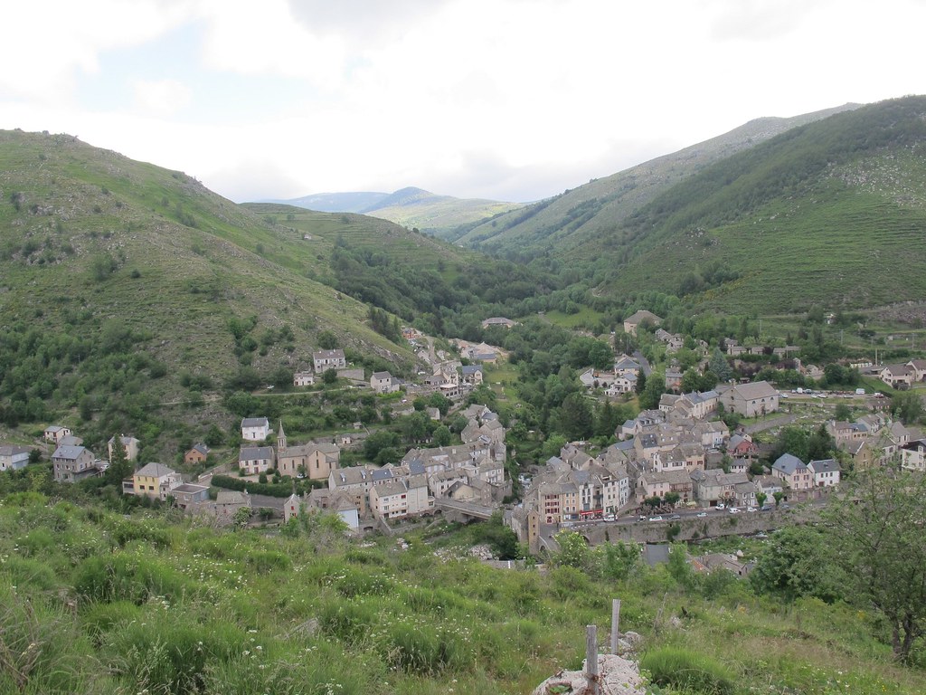
To cut to the chase, that day’s hike was harder even than the one up and over – and especially down from – Mont Lozere, and that’s saying something. But the photo above gives a bit of foretaste, a view of Pont du Montvert that we saw starting the day. Getting up to that point we averaged a bit over one mile an hour, and it didn’t get much better as the day progressed.
One bad thing about Montvert (“Greenhill Bridge”) – and even though it was “a beautiful little town” for a day off – was no WiFi. So I had to wait until we got to St. Julien (finally) to report that our wonderful day off “was sandwiched in between two humongous mountain climbs. Mont Lozere on Wednesday, and yesterday, Friday, 13.68 miles up and over ‘Signal du Bouges.'” And add that Friday’s hike “was tougher, it seemed to me,” and that’s saying something.
In fact, it was so tough that I didn’t write much about it when we got to our place for the night. Three lines in my journal: “Long day. Tough day. 13.68 miles, over ‘Signal du Bouges,'” then down our Florac bypass to St. Julien d’Arpaon. “Dragging tail into the the CG place.” The “CG place” turned out to be a kind of campground, Les Copains à Bord (Chambres-d’hotes), “Nestled in the heart of the village of Saint-Julien-d’Arpaon.” (Which in 2019 had a population of 93.) But looking back I can’t help but wonder why I didn’t write more about that “bypass.”
I’ll get back to the lodging later, which was quite pleasant as I recall. But why no notes later in the evening? Part of it was the distance, but not much longer than 12 miles up and over Mont Lozere. Part of it was no establishments to stop and refresh between Pont de Montvert and St. Julien. And part of it was that going “cross country,” off the beaten and established path, short-cutting it through thick forest and around big boulders and rocky path. (More than usual?)
To set the stage, Signal du Bouges is five miles out from Pont de Montvert and another 2.8 windy (as in “winding”) miles over to Mijavols. And somewhere west of of Mijavols we cut down through the deep woods, heading straight south (more or less) to St. Julien. And while I didn’t take many notes about the short-cut I did take pictures. Of reaching the top of Signal du Bouges, first through tussocks of clumped bush and up to forest clearings at the summit, strangely populated with numberless towers of piled-on flat rocks. (Where as I recall we had a packed-ahead lunch of sandwiches, apples and by-now-lukewarm water.)
But the next photos show smooth path, with distant mountains visible in the late afternoon haze, not hordes of trees crowding over you and big boulders blocking your way. I can only imagine that any stops in that cross-forest hike were few and far between, and that in such stops I was too bushed to haul out my tablet and take a picture. But we made it, finally, doing the last mile or so on the paved N106 highway. And I was never so glad to see pavement…
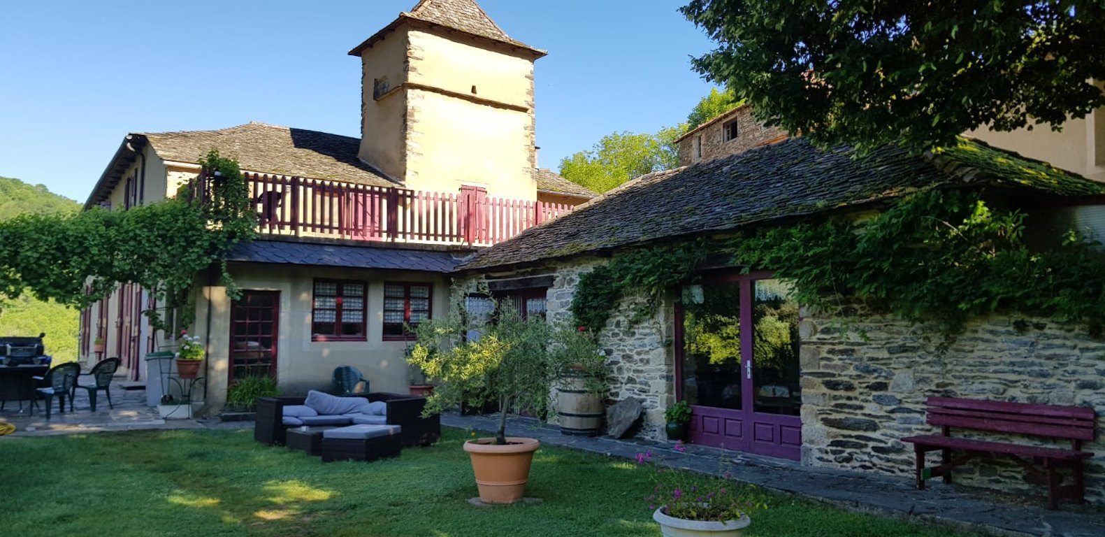
Les Copains à Bord is a campground in the sense that it’s rustic and stone-walled, with picnic tables, outdoor lounging tables and a spread-out lawn with “south-facing terrace.” The doors to the rooms all open to the outside (“independent entrance”), and to get to the communal dinner you head out and down to the main building. I took pictures of the meal, first a strange-looking but delicious cold pizza topped by a dollop of heavy cheese, and a main course of vegetable lasagna. (As I recall they had beer too.) Our lodging was a “cozy” one-bedroom cottage.
So that was Friday, September 29, but what happened on Saturday the 30th? I have some strange notes from that day, with our destination as LE MIMENTOIS – B&B in Cassagnas. (Not “Cassagnes,” with an “es” at the end. That similar-named town is 30 miles and over 11 hours hiking off to the west-southwest of St. Julien, so the answer to the question in the title is a definite “NO.”) Anyway, the Le Puy guidebook said it should have been a short, easy 4.8-mile hike, and Google Maps had it as a 5.7 mile hike on a different route. But as I wrote later, “Five mile hike turned into six. A bit more confusion finding this place, but turned out well. 2 beers after early shower. Mostly nice smooth hike along an Alpine-like river. [The “River Mimente.”] Until we got to what I thought was Cassagnes.” But I didn’t explain the confusion in my notes.
Some things I did note: Number One and as noted, it was supposed to be an easy day but wasn’t, in part because of my “frustration at not knowing what was what.” (Apparently in terms of “where the hell are we?”) Another thing? On the way I toyed with the idea of getting a new phone system myself, one where I could track where we were and where we were heading, instead of having to always trust Tom and Carol. (But I got over that, mostly, with some tweaks after getting back home.) On the plus side? “There’s beer here. I’ve had two, outdoors, as of 4:38 p.m. Turned out to be a nice afternoon.” That was in my pocket notebook, the one I carried in the “It’s European” thing that only looks like a purse.
Then there’s what I wrote in my official 2023 day planner, the one I stashed in my pack:
Saturday night, 9/30. Tonight we sleep. One big bedroom, 5 beds. Carol has taken one mattress and put it in the big shower room. The light is to my right & behind me thus the funny writing 2 small beers about 4:00 p.m. – Wine at dinner. Best dinner yet? Vichyssoise soup veggies chicken drumsticks + salad fromage and some almondine dessert. Very pleasant. Best dinner yet?
Looking back on my handwriting I’d say I had a pretty good time, and that the day turned out well after all. Another case of “ordeal and triumph,” which seems to happen a lot on a Camino hike. Or maybe “sin and redemption?” But as always on such hikes, “tomorrow is another day.”
And next up? On October 1 we hike on to Saint-Germain-de-Calberte, in what turned out to be a really eventful and awe-inspiring day. (“No really!”) Also next up? An anecdote or two for those who may by now be concerned about my occasional overindulging on the Camino. (Short take: “You work it off!”) In the meantime, here’s a look at one place we stayed. Stay tuned…
* * * *
* * * *
The upper image is courtesy of GR-70 Up From Pont De Montvert – Image Results.
The Wikipedia article on Cassagnas said the village “lies in the valley of the River Mimente.” Also:
Stevenson mentions the village… “I was now drawing near to Cassagnas, a cluster of black roofs upon the hillside, in this wild valley, among chestnut gardens, and looked upon in the clear air by many rocky peaks. The road along the Mimente is yet new, nor have the mountaineers recovered their surprise when the first cart arrived at Cassagnas
Some notes about the “heavenly” meal on Friday the 29th in St. Julien. Vichyssoise is a soup “made of cooked and puréed leeks, potatoes, onions and cream. It is served chilled and garnished with chopped chives.” In French cooking, “almondine” is a cooking technique that “involves incorporating almonds into a dish to enhance its flavor and presentation. Typically, this method involves toasting or sautéing almonds and then using them as a topping or garnish for various dishes.”
The lower image is courtesy of the Les Copains à Bord website, on the place in St. Julien.
And as always, you can see good information and photos at the site, Walking the GR70 Chemin de Stevenson – I Love Walking In France.
* * * *