Monthly Archives: November 2025

From Guildford to a creepy walled-in Anchorite in Shere…

*   *   *   *

Hillside view across to Guildford Cathedral
Guildford Cathedral … a relatively modern building, “having been consecrated in 1961.

*   *   *   *

November 22, 2015 – Here’s what I’ve described so far in posts about my hike last August on England’s Canterbury Trail. (What locals call the Pilgrims’ Way.) That’s the “historical route supposedly taken by pilgrims … to the shrine of Thomas Becket at Canterbury in Kent.”

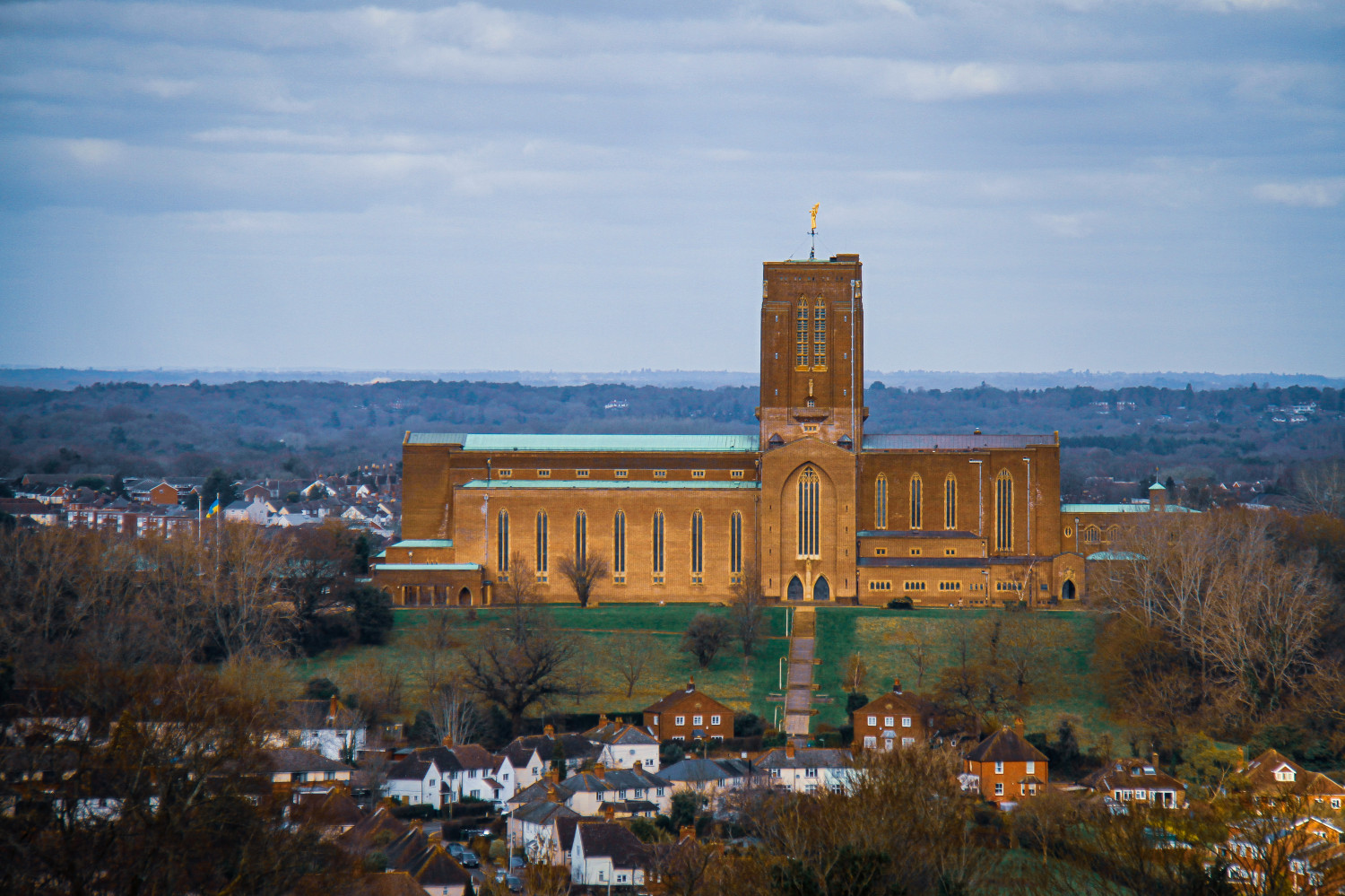
Officially it’s 119 miles, but detours to find suitable lodging made it 138 miles. At first I hiked with my brother Tom, and we left Winchester – at the western end – on August 11. (As detailed later, Tom’s wife Carol planned to join us on August 24.) After hiking five days – through places like Bishops Sutton, Alton and Farnham – we reached the site of our first day off – from hiking – in Guildford. (Silent “d,” the site of the upscale new cathedral shown above.)

More to the point, we finally got off St. Swithun’s Way (ptui!), the part of the trail that runs from Winchester to Farnham. We’d reached the much better North Downs Way part of the hike.

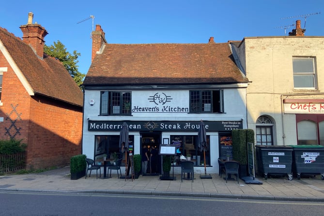
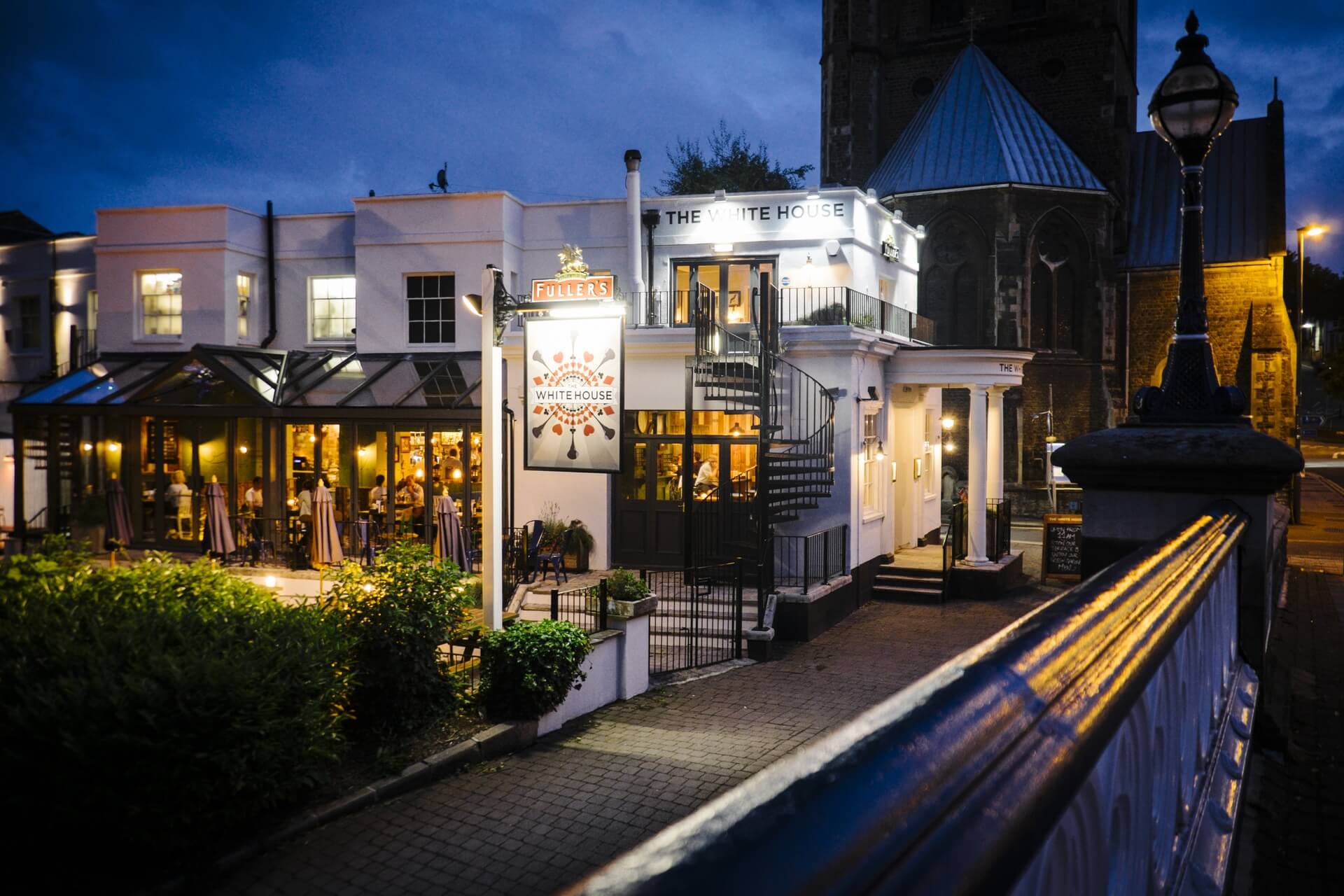
As the last post noted, on that fifth-day August 15 we “drag-assed our way in to Guildford,” after 12 miles, which we celebrated with a late dinner (and pint or two) at the White House pub. (On the banks of the River Wey, “this elegant yet cosy pub is said to overlook the very waters that supposedly inspired Lewis Carroll’s (Alice) Through the Looking-Glass.”) After dinner I collapsed into the living room sleeper sofa, followed by sleeping late and catching up on ZZZs.

On that day off (August 16) we visited Guildford Cathedral and got another Pilgrim stamp. The cathedral is way more modern-looking than I expected, but then it’s only been around a half century. (Said the pamphlet, adding that the unique building on Stag Hill was “built with bricks purchased for half a crown by thousands of ordinary people.”) And by the way, Stag Hill is a “prominent hill located in Surrey, England. It is situated to the southwest of Guildford, a historic town in the county. With an elevation of approximately 175 meters (574 feet) above sea level, Stag Hill is often categorized as a hill rather than a mountain due to its moderate height:”

The hill is renowned for its picturesque views and is a popular destination for both locals and tourists alike. From the summit, visitors can enjoy panoramic vistas of the surrounding countryside, including the Surrey Hills Area of Outstanding Natural Beauty … known for its rolling hills, dense woodlands, and charming villages, offering a tranquil escape from urban life.

And a tranquil escape from urban life – more precisely modern life, with all its “rush, rush, rush” – is just what we were after. (Along with a cold beer at the end of a long day.)

Resuming our trek on August 17, we hiked 13 miles – the longest day so far – from Guildford to Dorking, along the much-better North Downs Way. And had dinner and a pint at The Watermill, Dorking, seven minutes up the road from our place at the Travelodge Dorking.

But first, leaving Guildford we crossed over a footbridge on the River Wey, as people sculling rowed by beneath us. And for a long time we saw lots of Sunday-morning hikers; there’s a ton of hiking paths crisscrossing that part of the North Downs Way. That included a young couple with dad carrying a baby in a backpack-contraption that looked like something Rube Goldberg would be proud of. And about halfway to Dorking we got to the “small still partly agricultural village” of Shere. To get there we had to cross an old-time ford at the River Tillingbourne.

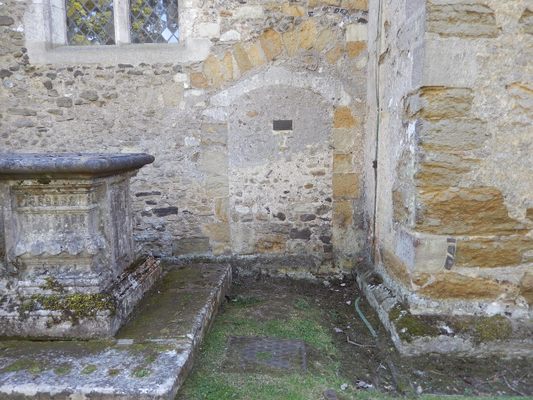
The ford consisted of a series of not-too-slippery rocks, which we gingerly tiptoed across. We got there just in time for light brunch at the Dabbling Duck. (A “vibrant cafe … situated in the picturesque village of Shere.”) Then, shortly after leaving the Dabbling Duck – Google Maps says it’s a three-minute walk – we came across St. James’ Church. There we found both a highlight and lowlight of the day. I’ll talk about the highlight in a bit, but the lowlight came during a guided tour given by a local church lady. It had to do with the “creepy walled-in Anchorite” in the title. Here’s what I wrote later about the “creepy hole in the wall” the lady pointed out:

It seems one Christine Carpenter wanted to be an Anchorite [in the early 1300s], dedicating her life to Jesus, by staying in this cubby hole in the wall of the church. The clover-shaped thing on the left was where she could receive communion. The other is where she could watch the church service. Then she changed her mind, but The People wouldn’t let her out. The church lady who related the story said nobody knows whatever happened to poor Christine, who wasn’t allowed to change her mind after that…

Which definitely piqued my interest. I checked Wikipedia, which said that by initially leaving her cell Christina violated her Anchorite vows and so was in danger of excommunication. She changed her mind again, but to make sure she didn’t change a third time, when readmitted to the cell her doorway was walled up. (The walled-up exterior is shown in my picture below.)

That church visit definitely freaked me out – shades of the Cask of Amontillado – but also made me think. And made me appreciate the heck out of my freedom to “walk free and own no superior.” Which brings us to the highlight of the day. While touring some other parts of the church I saw a poster with a saying attributed to St. Augustine, “it will be solved by walking.” (In Latin, “Ambulando solvitur.”) I did some research on this topic too, and found Solvitur ambulando – Wikipedia. (On the Latin phrase meaning “it is solved by walking.”) The term refers to “an anecdotal, practical solution to a seemingly complex philosophical problem. It is often attributed to Saint Augustine in a refutation of Zeno’s paradoxes of motion.”

But what does all this “book larnin'” have to do with the topic at hand? Just that ever since I started these long-distance Camino hikes in 2017 – think “Buen Camino!” – people at home have been asking me, “Why would anyone want to do that?” I could just answer, “Suit yourself, dumbass,” or give a more polite “Who wouldn’t want to do that?” But like any true aficionado I feel the need to spread the good word, the Good News of undertaking such a mission.

You know, besides the warm bed, hot shower and cold beer at the end of a long day’s hike.

I’ve found a number of answers that satisfy me, but that’s a bit like preaching to the choir. But that day in Shere led me to another answer, this one from a post on the Camino Quest website, Solvitur Ambulando: Is it really solved through walking? The writer said St. Augustine of Hippo may have used it in a metaphorical sense, “suggesting that some problems in life and faith can only be understood through action or experience rather than abstract reasoning:”

I find walking, hiking, and pilgrimaging all provide opportunities to solve life’s complexities (or at least contribute to solving). Walking the Camino is a journey unlike any other. Personally, I weave in and out of deep pondering and blank white space. Creative thoughts come at lightning pace. Smiles break out on my face, and tears sometimes flow. I am surprised by the range of emotions as my mind finds release from contemplating life’s challenges.

So I’d say St. Augustine was right, that walking really does contribute to solving life’s greatest mysteries, and that “It is also very good for our bodies and minds.” Which brings us back to that creepy walled-in Anchorite and the question I would ask Christine Carpenter, “Why would anyone want to do that?” I’d much rather enjoy the heck out of my freedom to “walk free and own no superior,’ which as Walt Whitman said “encapsulates the essence of true freedom.”

In the next post we’ll move on from the creepy walled-in Anchorite in Shere toward further adventures in Dorking, Sevenoaks and Dunton Green, our second day off and home of the Rose and Crown, Vintage Pub. Something I’m guessing Christine Carpenter never got to enjoy…

*   *   *   *

An outside view of the Cell of the Anchoress of Shere but “not on my Bucket List…”

*   *   *   *

The upper image is courtesy of Guildford Cathedral – Diocese of Guildford: The “‘Mother Church’ of the diocese with a unique and high-profile ministry. Relatively speaking, it is a modern cathedral, having been consecrated in 1961. Its construction could not have happened without the generosity and support of the local community.” As to that local support see Guildford Cathedral – Wikipedia:

The Cathedral Committee … launched the ‘Buy-a Brick’ campaign in 1952. Between 1952 and 1961 more than 200,000 people paid 2s 6d (equivalent to £5 in 2023) to sign their name, or the name of another person on a brick. Elizabeth II and Prince Philip both signed bricks, which are on display inside the cathedral, along with bricks signed by other members of the Royal Family.

It was built on Stag Hill, “so named because the Kings of England used to hunt there. Its solid red brick outline is visible for miles around. Whilst in 1932 this was far outside the town of Guildford, the growth since then has already begun to wrap around the cathedral to the west and south.”

The lower image is courtesy of Cell of the Anchoress of Shere – Atlas Obscura, which added: “Christine broke out of the anchorage after almost three years and attempted to rejoin society.” See also – aside from Wikipedia – Secret Surrey: The woman who chose to spend her life in a cellThe Anchoress of Shere, Christine Carpenter – Shere DelightCell of the Anchoress of Shere – Atlas Obscura, or Christine Carpenter – Surrey Cultural Lives. For more on Anchorites see Wikipedia: Such people were required “to take a vow of stability of place, opting for permanent enclosure in cells often attached to churches. Also unlike hermits, anchorites were subject to a religious rite of consecration that closely resembled the funeral rite.”

See also The Anchorite Tradition of Voluntary Incarceration and Devotion to God:

“An anchorite … was a person who chose to “live alone in prayer to worship God, unceasingly and without distraction.” Although other Christian ascetics share the goal of the anchorite, for instance hermits who lived in the deserts, there are certain features that separate the former form the latter. Generally speaking, an anchorite refers to one who was “walled into a small cell which was attached or ‘anchored” to a church or oratory.” The anchorite tradition was particularly widespread in the British Isles. (Emphasis added.)

*   *   *   *

From Bishops Sutton to Alice’s Looking Glass…

*   *   *   *

A little taste of heaven – after a hard first full day of through-hiking, from Bishops Sutton…

*   *   *   *

Welcome to the “Georgia Wasp…”

This blog is modeled on the Carolina Israelite. That was an old-time newspaper – more like a personal newsletter – written and published by Harry Golden. Back in the 1950s, people called Harry a “voice of sanity amid the braying of jackals.” (For his work on the Israelite.)

That’s now my goal as well. To be a “voice of sanity amid the braying of jackals.”

For more on the blog-name connection, see the notes below.

In the meantime:

November 4, 2025 – In the last post my brother Tom and I finally started the Canterbury Trail.

Kind of.

Actually, our first two days didn’t meet the definition of Thru-hike. “Hiking an established long-distance trail end-to-end continuously.” That was because of a glitch in lodging; we couldn’t find a good place to stay between Winchester and Alton. (A distance of some 18 miles.) So the first day we hiked halfway, then took a bus back to the apartment in Winchester. (Which held half our stuff, for what should have been a lighter if not easier hike.)

So Wednesday the 13th we bused from Winchester to Bishops Sutton, then hiked the rest of the way, to the Alton House Hotel. (For the first time lugging fully loaded packs.) We ended the day with a touch of Heaven’s Kitchen – hot meal and cold beer – but I’m getting ahead of myself.

Back to Wednesday morning. We took full packs – mine at 16 pounds – and took the bus from Winchester to Bishops Sutton. (A mile east of Alresford – “Al’s Ferd” – where we stopped the afternoon before.) And home to a lot of watercress cultivation, “due to its chalk geology and the calciferous River Alre allowing it to grow in the beds of Chalk streams.” Meaning we saw lots of watercress “farms” (more hydroponic) that first full day’s hike from Bishops Sutton. And as noted last post, this was after we’d stopped that first “half-weight-day” for lunch at the Bush Inn, Ovington, in the process of having its roof re-thatched. So we began this day’s hike as well on St. Swithun’s Way, a path that I found “weighed in the balance and found wanting.” I found it neither well marked nor well kept, plus there were few places to stop; more on that in a bit.

But before going further, a preview of coming attractions. That Wednesday, August 13 we hiked from Bishops Sutton to the Alton House Hotel in Alton. Thursday we hiked a short 7.4 miles to the Farnham House Hotel in Farnham. (On Alton Road.) Friday the 15th we hiked 12.4 miles to Guildford Station – the “d” is silent – at 33 Farnham Road. We stayed there two nights for our first day off. (After five days hiking.) And now for some background details.

I’ll start with why I found St. Swithun’s Way “wanting.” Aside from a total absence of fellow through-hikers, the path was often overgrown; at times only six inches wide between brush and bramble on both sides. And the path markers left much to be desired; often missing and sometimes just plain wrong. Plus as noted, few places to stop and refresh.

An example of a rare place we found to stop: Somewhere between Bishops Sutton and Alton, a place called the Tack Room. (A “tea place,” meaning no beer.) We met two local oldsters – close to our age? – who took great interest in our hike and debated long and hard on how to get to Alton. And getting there we passed through more sheep fields – “watch where you step!” – then through another overgrown patch of trail. I didn’t write much about that day, our first with full packs, except to say hike should have taken six hours but ended up taking nine. “We drag-assed into Alton, then showered and had dinner at the ‘Heaven’ Mediterranean steak house down the street.” (Heaven’s Kitchen Alton.) And that I “collapsed into bed about 9:00 pm.”

It does usually take a day or two to round into shape.

That first full day’s hike did have some moments of beauty and solace. Like the fields of flocking sheep and “shades of Van Gogh” fields of wheat. Plus it was overcast and a bit cooler than Tuesday, which helped. (The UK weather had been much warmer than expected.) Also, right about that time the Pilgrims’ Way Guidebook started talking a lot about Kissing Gates:

The kissing gate is often the subject of chatter about the origins of its amorous-sounding name. Consisting of a semi-circular, square or V-shaped enclosure on one side and a hinged gate that swings between two shutting posts, it allows one person at a time to pass through but keeps livestock out… As for the title, the prosaic answer is that it derives from the fact that the hinged part touches – or ‘kisses’ – both sides of the enclosure rather than being securely latched like a normal gate.

So much for that amorous-sounding gate. On the 14th we left the delightfully retro Alton House Hotel – at 9:10 – and stopped for lunch in Bentley, after five and a half miles. That afternoon we ended up at Farnham House Hotel, another delightfully retro inn, but hard to find. (Part of the slow going, “mostly due to poor upkeep and ‘iffy’ signage.”) Google Maps said it was only three miles, but not on “St. Swithun.” The iffy signposts took us way north.

For example, later that day we found a sign pointing northeast; it said, “Farnham 4m – 53 km.” Which I found a perfect metaphor for the FUBARs on St. Swithun’s Way. We believed the sign but it took us the wrong way. “Had to backtrack a bunch, once again. And note, 53 kilometers is some 33 miles, not four. My advice: Hiking to Canterbury … go the Google Maps way. Which I’m sure Chaucer’s Canterbury pilgrims would do if they had Google Maps back then.”

The day’s highlight? A late lunch (and pint of Cruzcampo beer) at Farnham Royal Pub in Bentley. I noted, “Google says we’re three miles from tonight’s lodging in Farnham… But it’s slow going, mostly due to poor upkeep and iffy signage.” We eventually did make it to Farnham House Hotel on the 14th, “a delightful country manor house located on the outskirts of Farnham in Surrey,” no thanks to St. Swithun. (And after hiking through a pasture full of horses.) If you check Google Maps you can see that coming from the north – after being misdirected by signage – we had to take a left on Runwick Lane, then head south on Chamber Lane. Then hit Alton Road, take a left and then head back up north for ten minutes up that long driveway to the Hotel.

That was just part of the backtracking we had to do that Thursday.

Our hike on Friday the 15th started better. For one thing (as I wrote later), “Saw the first NDW sign at 9:15 a.m., after leaving the Farnham lodging at 7:50. 11.95 GBP for their breakfast but it was really good. Lots of fruit, juice, coffee and cereal. And so far the NDW looks a whole lot better than St. Swithun’s Way.” To translate: We had to pay extra – 11 British Pounds – for breakfast, but it was worth it. Then, hiking out of Farnham we saw our first sign indicating we were finally off St. Swithun’s Way (ptui!) and on to the North Downs Way. Which I found much more pleasant to hike on; better maintained, smoother well-kept trails and better signs.

We hiked through Runfold Wood, a 30-acre nature reserve east of Farnham, and at 2:20 we reached Puttenham, famous for “lots and lots of hops.” (From which they make beer.) In honor of that we stopped at the Good Intent Pub, with its “cosy atmosphere,” spacious beer garden and a menu “full of freshly prepared pub classics and seasonal dishes.”

Leaving Puttenham the Trail eventually goes through a tunnel under the busy Guildford and Godalming Bypass. Past that and the Watts Gallery we saw a long line of open fields to the left. The last one we saw – before turning left (north) up to Guildford – had its northeast corner bordering on the Ergo at Work Ltd shop, which we didn’t know at the time. What we did know was that the official Trail bordered one last long open field, which led to trouble.

The official trail was in deep woods, but parallel to it – bordering the open field – was a nice sunny smooth dirt path, open to the sky. For a while we hiked in the woods, then switched to the parallel dirt path. Between the smooth path and official trail ran a line of thick brush, much of it brambly, overhung with more trees. Looking ahead I saw Tom head off into the brush, what I thought was answering a call of nature. So I took off my pack and waited. And waited. After a bit of time I heard Tom calling. I yelled back but he evidently didn’t hear me.

That went on for a while, him calling but not hearing my response. (“Bedroom voice?”) I climbed back through all the bramble-brush to the official trail, but that didn’t help. In time I figured “No problem. I know the address. All I have to do is get to Guildford, find a pub with wifi and contact Tom by WhatsApp. Piece of cake.” So I set off east, heading toward Portsmouth Road, where I’d take a left and head up to Guildford (and a pub). That was a strange feeling, being alone and out of touch in this faraway land, but also a touch exhilarating…

In time I got to Portsmouth Road, where the Canterbury Trail keeps on toward Dorking. But just to make sure – before heading north – I hiked south a bit, then a bit east. Then from the west came a man on a bike who said, “Some guy a way’s back keeps calling out. I think he’s looking for you.” So I backtracked once again, and eventually met up with Tom.

The result? That August 15 we “drag-assed our way in to Guildford,” after hiking 12 miles (at least), but on the North Downs Way. (“Not St. Swithun’s.”) Which we celebrated with a late dinner – and a pint – at the White House pub on the River Wey. (“Perched gracefully on the banks of the River Wey, this elegant yet cosy pub is said to overlook the very waters that supposedly inspired Lewis Carroll’s (Alice) Through the Looking-Glass.”) After that I collapsed into bed – actually the living room sleeper sofa – followed by sleeping late and catching up on rest.

*   *   *   *

The White House Restaurant, bordering the River Wey in Guildford…

*   *   *   *

The upper image is courtesy of Heaven’s Kitchen Alton Uk Image – Image Results. And a word about that “Sutton.” The name derives “from Old English elements ‘sūth’ signifying ‘south’ and ‘tūn’ indicating ‘enclosure or settlement.’ Historically, it denoted southern farmsteads or villages, playing a significant role in Anglo-Saxon England as agricultural hubs. Many places named Sutton evolved into manorial estates and local marketplaces documented in the Domesday Book.” (Meaning Of The Name Sutton.) So this particular Sutton once belonged to the Bishop of Winchester.

Some things I’ll put here so as not to disrupt the narrative: On the 12th we stopped and got a stamp for our Pilgrim Passport at St Swithun’s Church, Martyr Worthy. Then – speaking of iffy signage – one time on August 13 we missed a turn because the SSWay marker was covered with brush. We were changing from one paved road to another. Then passed through a long field of what looked like stunted wheat. Then a lot of sheep fields.

Another note: Our spreadsheet had the name of the apartment at 33 Farnham Road as “Guildford Station.” But more properly that term applies to the Guildford railway station, “one of three main railway junctions on the Portsmouth Direct Line and serves the town of Guildford, in Surrey, England. It is 30 miles 27 chains (30.34 mi; 48.8 km) down the line from London Waterloo.” (Wikipedia.) The station is a five-minute walk from “Guildford Station Apartment, 33 Farnham Rd.”

The full link: Kissing Gates: How Did They Get Their Name? | HistoryExtra. As for the prosaic answer to its amorous-sounding name: “That hasn’t stopped many clinging to a more romantic notion: that the first person to pass through would have to close the gate to the next person, providing an opportune moment to demand a kiss in return for entry.”

North Downs Way – Wikipedia adds that it’s a long-distance path that opened in 1978 and runs 153 miles “west–east along the North Downs, the range of chalk hills after which it is named, from Farnham in Surrey to Dover in Kent.”

The link Answer the call of nature – Idioms by The Free Dictionary provides a lot of in-depth history.

Re: “Bedroom voice.” Back in 1966 – I was 15 – my best friend’s girlfriend told me that. “You have a bedroom voice.” Which comes in handy sometimes, but not this day on the Canterbury Trail.

The lower image is White House Restaurant Guildford Uk River Wey Images – Image Results. See also White House | Restaurant Bar | , UK | DesignMyNight, with the full quote:

Perched gracefully on the banks of the River Wey, this elegant yet cosy pub is said to overlook the very waters that supposedly inspired Lewis Carroll… Step through the doors and you’ll find a space that feels both timeless and full of character – think glowing fireplaces, wooden floors, and an inviting buzz that makes every visit feel like an escape from the everyday… Outside, the riverside terrace is the real show-stopper. On sunny days, it’s the perfect spot to sip a chilled glass of rosé or a pint of Fuller’s Frontier while watching the river drift by – you might even half-expect the White Rabbit to hop past. 

We enjoyed our fish and chips (plus pint) on that show-stop riverside terrace, watching the River Wey as it glided by, and as four local ladies chatted away and the sun set in the west.

*   *   *   *