* * * *
* * * *
To get up to date, “last Wednesday” (September 27, 2023), we three hikers – myself, brother Tom and his wife Carol – left Hôtel Restaurant La Remise, in Le Bleymard. That day we faced a 12-mile hike to Le Pont-de-Montvert. (French for “Greenhill Bridge.”) The challenge that day was climbing up and over Mont Lozère. (A “massif 5,574 ft above sea level … within the Cévennes National Park,” and what that guidebook from Le Puy called Sommet de Finiels.)
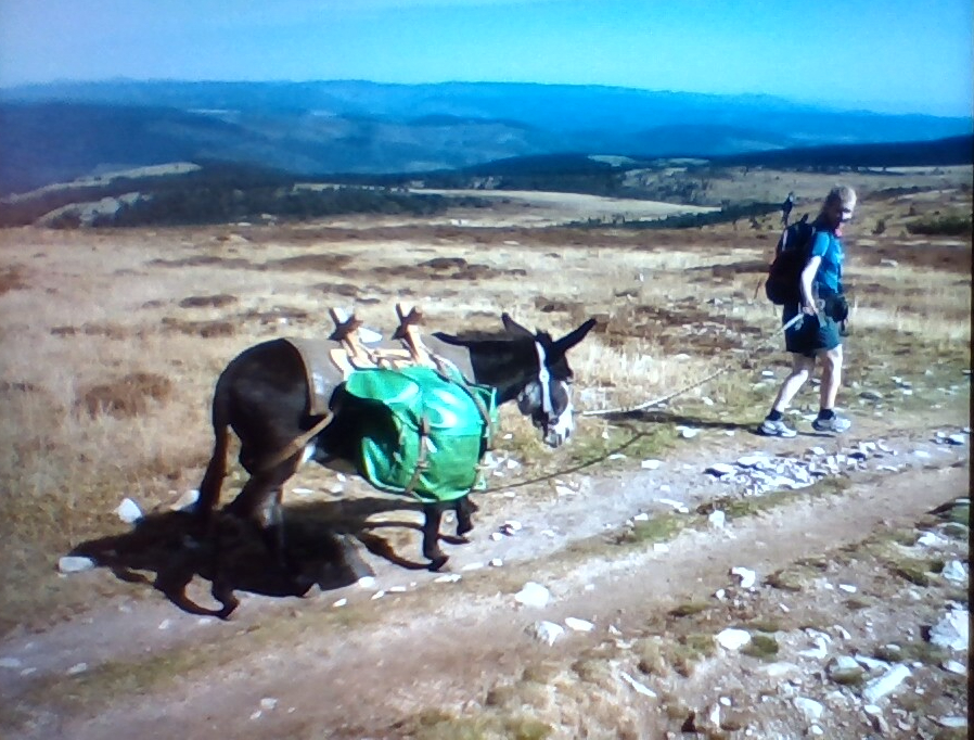
That hike was so challenging I had to split in two separate posts. That is, the last post noted Mont Lozere was the highest point on the GR 70, “a popular long-distance path following approximately the route” Stevenson traveled, not to mention “quite a hike.” And it was. But one of the fun parts was seeing “this lady and her donkey, a modern day version of Modestine, in the manner of the original R.L. Stevenson hike.” And also making it to what seemed like The Top of the World, even though there were “no trees, no vegetation” but awesome views. (Another nice event was stopping for a beer on the way up, but I’ll talk about that later.)
So anyway, Stevenson reached the summit the morning of Sunday 29 September, 1878, “having spent the previous night camped in the woods beyond Le Bleymard.” From the top of Lozere he saw “the hazy air of heaven,” and looking down “a land of intricate blue hills beneath his feet… These were the Cévennes of the Cévennes.” Today’s version of his hike follows “a draille (drove road) across the mountain, marked by montjoies (standing stones).”
As for us, we followed the drove road and saw lots of those standing-stone mounds, but for another take on the climb see Walking the GR70 Chemin de Stevenson … Walking In France:
As the path approaches Mont-Lozère and climbs Col de Finiels (the highest point on the walk), the vegetation – and the livestock – disappears… [T]all rock pillars mounted along the edge of the trail guide travelers [but] during the walking season, the path is open and exposed to fierce sunshine and biting winds.
The winds weren’t too bad that day, but at this point it occurs to me that so far I haven’t said much on how it actually feels on those long hours hiking. Especially a long hike to “the highest point on the walk.” How you pass the time? Mostly you do a lot of thinking, and remembering, mostly because there isn’t much else to do. You can admire the scenery, and in the Cevennes it was pretty awesome, but after a while that gets to be old hat. Plus a lot of time, going up or down those steep rocky trails that seem so much a part of “The Trail,” you focus mostly on not taking a wrong step, twisting an ankle or a knee. (Or “slip and fall;” a bit of foreshadowing.)
There is one relative constant. Most places you see and hear a lot of dogs, usually approaching or leaving a town or city. (Though not so much climbing Mont Lozere.) And each time I think to myself, “Roof, roof… ‘Ya think I shoulda said maybe DiMaggio?'” It’s from a really old joke:
Back in the 1930’s a man takes his dog to a talent agent on Madison Avenue. “You won’t believe it, but my dog can talk!” The agent is skeptical, so the man says, “Watch this. Rover, what’s that on top of a house?” The dog responds: “Roof, roof!” The agent is unimpressed and rolls his eyes. The man sees that and says, “No really, listen to his. Rover, how does sandpaper feel?” The dog replies, “Ruff, ruff!” The agent moves around his desk and tells the man to leave. The man asks for one last chance and says, “Rover, who is the greatest baseball player of our age?” The dog enthusiastically responds, “Roof, roof!” The man tells the agent, “Did you hear that? He says Babe Ruth is the greatest player of our age!” The agent grabs man and dog and throws them bodily out of his office. Out in the hall Rover sits up, dusts himself off and asks the man, in a thick Bronx accent. “Do you think I shoulda said maybe DiMaggio?”
It happens every time on the Camino when I hear a dog bark. I think, “Roof, roof,” and then, “Maybe I shoulda said DiMaggio?” And every time I chuckle, just like I did writing this out.
But back to the GR-70: We started out on a paved road, then onto a hard-packed and pretty smooth dirt road. As usual this hike the mornings were fresh and clean, with deep shadows alternating with bright sunlight. This day started with rolling hills off in the distance, framed by barbed-wire fences and tall wheat grass. Early on we met up with three older-lady hikers, and stopped to chat when we heard them speak English. Then a pine forest where the path turned a bit more rocky, and every so often a car would pass by, heading up the mountain. Further on fewer and fewer trees and the path got narrower. Actually the climb up wasn’t too bad.
One nice thing about that hike up: There’s a place called Station du Mont Lozère on the way, a mere 3.2 miles out of Bleymard. (And about five and a half miles from Finiels, “a hamlet on the slopes of Mont Lozère,” past the summit.) The Station is best known as a winter ski resort, but this day in late September I knew it was the only place to get a beer until day’s end. So even though it was only 11:00 a.m. when we got there, I ordered a beer. (Contrary to my general rule not to have a beer before noon; this day there were “exigent circumstances.”)
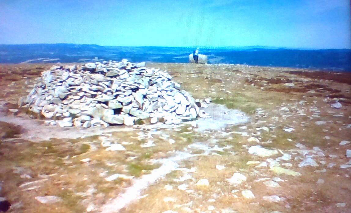
One thing I remember “even to this day” about reaching the summit – finally – was how table-smooth it was, and full of rock circles and stone mounds. Another thing I remember was the cluster of signs showing distances to various parts of the hike. One said Le Monistaire, back where we started our second day’s hike, was 135 km (83.88 miles) away. Another said St.Jean du Gard was 95 km (59 miles) away, and that’s where we were to end our hike. (And according to our schedule we would get there on October 3, 144 years to the day after Stevenson got there.) Yet another sign said Pont du Montvert was still 11.2 km (6.95 miles) away. (Meaning “that’s how far we still have left to hike, after climbing UP and over Mont Lozere!?!”)
So all in all, reaching the top of Sommet de Finiels (another name for Mont Lozere) was a true mountaintop experience. And speaking of “What do you do after [such] a ‘mountaintop’ experience,” our goal at the end of the day was still Le Pont-de-Montvert. (French for “Greenhill Bridge.’ That and the usual end-of-day warm bed, hot shower and cold beer.) And looking ahead – as I did back at home – I saw that Montvert stands “at the base of the south-facing slopes of Mont Lozère” and features “the stony granite-built traditional aspect of its closely built centre,” which is where we’d end up at day’s end. I’d also read this in pre-trip research:
The village is named for its hump-backed bridge (en dos d’âne) that spans in a single arch the swift-flowing Tarn – here near its source. The bridge is guarded by a defensive tower at the village end, now with a more amiable function: village clock. Medieval in aspect, bridge and tower date to the 17th century.
It sounded lovely, and on top of that we would end our six straight days of hiking with our second – and last – day off before the trip ended in St. Jean du Gard. But to get that blessed second day off we had to climb “all the way back down” from Mont Lozere.
That turned out to make it a long and challenging day. So long and challenging that I didn’t make any notes until the day after, during that second day of rest. One thing I wrote, on the hike over Mont Lozere: “The longest day so far, 10 hours on the Trail, a full 12 miles. Some bad-ass rocky paths, especially near the end when you’re good and tired.” I also wrote about the great view at the summit, “not too windy, but at the end of the day, after 10 hours on the Trail, each rocky foot-step hurt like hell. Back hurt, feet hurt, not fun.” But as usual on a Camino hike, after the hot shower, fresh clothes “and three beers, with salad, things looked better.”
“Tomorrow” – Thursday September 28 – we would thoroughly enjoy our second day off, but I’ll write about that in the next post. That and the challenge of Tom trying to figure out a way “to bypass that big-ass Florac loop, and short-cut down to St. Julien.” I added, “I hope it doesn’t involve more rocky [bleep]ing trails. I’ve had more than enough of those yesterday, sore-footing it into Pont de Montvert.” (I wrote the “[bleep]” in the original.)
* * * *
* * * *
The upper and lower images are both my photos.
Re: The “Roof” joke. See Moral of a silly old joke … A guy has a talking dog. He brings it to a… – Unijokes.com, or Roof! Rough! Ruth! – Justin Li. Or search “joke talking dog roof dimaggio.”
The link to Station de ski du Mont Lozère | Station à 1702 mètres emphasizes it as a ski resort. When we were there I noted mostly the good restaurant and cold beer.
Re: Finiels. See Wikipedia., which added that it “has a small number of inhabitants… The nearest village with convenience shopping is Le Pont-de-Montvert, roughly 6 kilometres (3.7 mi) to the south.”
Re: “My general rule.” I came up with that rule on 2017’s hike on the Camino Frances. On the last 10 days we switched from hiking to mountain bikes. One day I had a beer for an early lunch, before noon, and later that afternoon “my bike ran me into a ditch!” See “Hola! Buen Camino!” – Revisited:
We were zooming downhill one afternoon. I tried to adjust my left pantleg, and the next thing I knew I was laying in a ditch, bleeding like a stuck pig. And not just any ditch. A nice deep ditch covered with thorns and brambles on the sides and bottom. The “stuck pig” part came when my Ray-Bans gashed the bridge of my nose, causing it to bleed profusely…
Actually that was merely the second of three major biking mishaps in 2017.
* * * *