
This is something like what I saw – unexpectedly – canoeing 440 miles on the mighty Yukon River…
* * * *
 I just got back from two weeks canoeing the Yukon River. (That’s also the caption for the Wiki-photo at left.) And the “mighty Yukon” is the last place on earth I would expect to see a lady sun bathing.
But one moment, out of nowhere, there she was…
You can see the full story below. I just wanted add – at least for now – that in the picture at the top of the page, for the Yukon setting, you will need to imagine no sand. (And no “Bikini Bottom,” for that matter.)
Instead, imagine a bend in the Yukon River, a canoe turned over next to a “good campsite,” and a red blanket, on which lay the “naked lady.” (And I think she was a blonde…)
But first, some background.
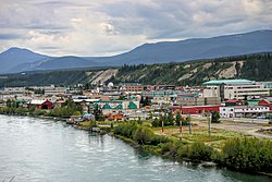 My last post – “Many furriners” – noted it was last July 26 – a Tuesday – that my brother and I started the drive from Utah to Whitehorse, Yukon Territory.(Shown at right.) Four days later – on Friday, July 29 – we met up with my nephew, fresh out of the Army.
From there we drove to Skagway, Alaska. The following Monday – August 1 – we started a four-day hike on the Chilkoot Trail. (The “meanest 33 miles in history.”)
And here’s a news flash. There’s a reason they call it the “meanest 33 miles in history.” I’ll be detailing that little jaunt in a later post. (To be titled, “On the Chilkoot &$%# Trail!”)
But back to the Yukon River. Once we three finished the “Chilkoot &$%# Trail,” my nephew flew back east – to Philadelphia – and from there to Penn State University, to begin fall classes.
That left two old geezers – my brother, 70, and me, just turned 65 – to paddle our canoes “up*” the Yukon River. From Whitehorse to Dawson City, that’s a distance of 440 miles, and we covered it in 12 days. (Not counting the full day we took off on Sunday, August 14, in beautiful Carmacks, Yukon Territory, to rest and refit.)
Before we left I checked a web-post, Canoeing the Yukon River – Our Time Machine is a Canoe, written by Murray Lundberg. Some years ago he did pretty much the same trip as ours, with his son Steven. One big difference: They started at the Lake Laberge Campground – instead of Whitehorse – “to cut down the still-water distance that we’d have to paddle.”
 Which is another way of saying that paddling a canoe on Lake Laberge* – shown at left – is a real pain.
But that’s a story for another post.
Now back to the naked lady…
It was Friday, August 12. We were a day away from Carmacks, and had been on the river five days already. (And finally made it off “Lake &^%$# Laberge.”) About 4:00 my brother was way ahead of me, when he went around a right-hand bend and looked like he was heading to shore, for a break.
There followed one lo-o-o-o-o-o-o-ng right-hand curve in the Yukon, one that seemed to last forever. It was getting late and we were looking for the “good camp” listed in the guidebook.
When I finally got to the end of the long right-hand curve, I could see something, way off, a half-mile or so ahead. (Where the river turned sharply to the left.) I saw two small dots, near the bank – at what I later learned was the “good camp” we were looking for. One of the dots was light and the other dark. The lighter dot kept moving, to the left, downriver, and I figured it was my brother. But I wasn’t sure which “dot” to paddle toward.
So I took the middle course, and as I got close to the bend in the river, I could see the dark dot was a green canoe, turned over. (Which we never do.) Then – I began to see – there was a red blanket next to the canoe, and something light on it.
 That turned out to be the aforementioned naked lady – a reprise interpretation of which is shown at right – laying there in her birthday suit, face down, for all the world to see. (Or at least two passing canoeists.)
Which brings up the current on the Yukon River.
Generally the current is pretty fast. It ranges from over four miles an hour up to seven miles an hour in some places. (Except on “Lake &^%$# Laberge.”) That’s the kind of current that helps you paddle 440 miles in 12 days. But it also means that when you see something totally unexpected, by the time you recognize it, the current is already moving you downriver. (Creating a flash in the pan, so to speak.) Which meant that by the time I recognized the naked lady as a naked lady, the current was already pushing me farther down-river.
Besides, my brother was already downriver, waiting. (Having gotten an eyeful himself.)
As to the lady’s identity: The last day on Lake Laberge we had landed – for a much-needed break – next to a couple in a tandem canoe. They were from Turin, Italy, and later on in the trip we kept running into them, further downriver. They pulled into Carmacks not too long after we did, on Saturday, August 13. And when we finally got to Dawson City – a shade after 3:00 p.m. on Saturday, August 20 – they had gotten there a few hours before.
So it was my brother’s opinion – first expressed at Carmacks, on the 13th – that the “better half” of that nice Italian couple was the mystery lady, sunbathing au naturel on the banks of the Yukon. (Besides which they took the one “good” camping spot on that stretch of the river.) Unfortunately, neither one spoke very good English, and there seems to be no diplomatic way to translate, “Was that your wife’s naked butt we saw back on Friday the 12th?”
But enough about the Naked Lady on the Yukon.
This is the first of several posts I plan to write about our other adventures this month. And as noted before, those adventures started with our hike on the Chilkoot Trail.
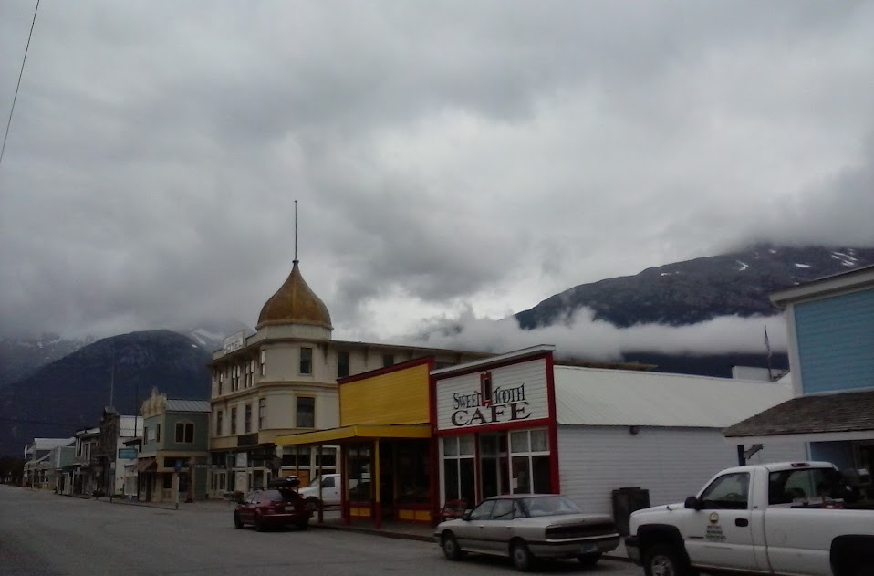
This was after checking out the Yukon River, in Whitehorse, after checking out of our hotel. Then we drove the 110 miles or so to Skagway itself. That’s where – among other things – we had to get a special permit to hike the “Chilkoot &$%# Trail.” (They won’t let just anybody on there!)
And among other other things, we also learned we’d lost an hour crossing into Canada. That’s because there’s a special Alaska Time Zone, one hour earlier than the Pacific Time Zone they use in British Columbia and the Yukon Territory.

However, after further review – for this post – I found out that’s not the case. See for example Footprints on the toilet seats? – Reuters. (“One Norwegian tourist in Malaysia said, ‘They can be very messy because people don’t seem to know how to use the toilets. You find black spots, footprints on the toilet seats, and there’s water everywhere.'”)
Or Footprints on the Toilet Seat: Guidebooks for Novice Travelers, noting Chinese tourists – for example – who behave “in ways the locals saw as inappropriate.” On that note see also Travel pro-tips from the Chinese government: Don’t leave footprints on toilet seats [or] spit in hotel pools. All of which is – I suppose – one reason they say Travel Broadens The Mind.
(And you might even see a naked lady along the way.) But one thing both a good travel experience and a good pilgrimage will teach you: “There’s No Place Like Home.” (As shown below.)
I’ll be writing more about my August adventures, including the next post:
* * * *

As Dorothy said in The Wizard of Oz, “There’s no place like home!”
* * * *
The upper image is courtesy of Sun tanning – Wikipedia, the free encyclopedia. The caption: “A woman sun tanning on a Portuguese beach.”
Re: Paddling canoes “up” the Yukon River. To most people, going “up” means to go north, while to go “down” means to go south. (With “over” meaning east or west.) But to go “down” a river means to go downstream. And while many rivers flow “down” or south, the Yukon – like the Nile – flows north. So while we were paddling “up” north, we were also paddling “down,” as in “downstream…”
Re: Lake Laberge. Most people know the name as “Lake Labarge,” from the poem by Robert Service, The Cremation of Sam McGee. In the poem, “the narrator winds up hauling the body [of Sam McGee] clear to the ‘marge [shore, edge] of Lake Lebarge.'” So Service changed the name to “Labarge” to rhyme with “marge.” (See artistic license – also known as “poetic license” – at Wikipedia.) Also, the image of Lake Laberge is courtesy of lakelaberge.ca.
The lower image is courtesy of The Wizard of Oz – Wikipedia. See also No Place Like Home – Wikipedia, which noted that – aside from the famous line in “Wizard of Oz” – the phrase may also refer to “the last line of the 1822 song ‘Home! Sweet Home!,’ (John Howard Payne and Sir Henry Bishop); the source of inspiration for the other references here: ‘Be it ever so humble, there’s no place like home,’” and/or “‘(There’s No Place Like) Home for the Holidays,’ a 1954 Christmas song most famously sung by Perry Como.” For a “live” version, see also There’s No Place Like Home – YouTube.

 Last Tuesday – July 26 – my brother and I started the long drive north, from Utah to
  Meanwhile it looked like there was a fire to the west of Great Falls, as shown in my photo at left. I figured there was a wild fire to the west of the city, which would explain the smoke we smelled driving up to exit 278. And it turned out my hunch was right. (As shown by the front page of the next day’s
 And that would be on the famed
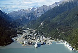
  So anyway, we hit the city limits of Whitehorse at 7:00 p.m. (Pacific Time, or 10:00 p.m. ATL Time.) Saturday morning we checked out the Yukon River for the canoe part of this expedition. (That is one FAST current, estimated at about 7 miles per hour.) Then we drove to Skagway and got there early Saturday afternoon. (To prep for the hike on the Chilkoot Trail, as seen at right, in winter.)