* * * *
* * * *
July 27, 2025 – One week from next Tuesday I’ll fly back to London. Then hook up with hiking partners and take the train to Winchester to start the Pilgrims’ Way. (Canterbury Trail.) So as the last post noted, “it’s time to get serious. Time to see what kind of terrain we have to look forward to.” And that last post got this pre-trip recon as far as Dorking, 49 miles from Winchester.
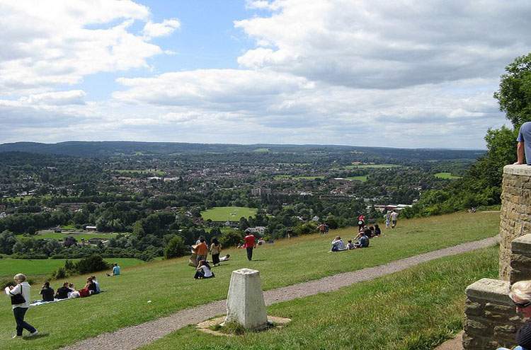
Dorking is a market town in Surrey, 21 miles south-west of London. And it is surrounded on three sides by the Surrey Hills National Landscape and close to Box Hill and Leith Hill.
Which sounds great, but first a note on arriving in London on August 6. I’m scheduled to arrive at Heathrow airport at 6:30 in the morning, but my check-in time isn’t until 2:00 p.m. That means I’ll have plenty of time to meander. So first I’ll take the Elizabeth Line to Paddington Station, which should take 30-40 minutes. From there I have a choice… Or do I?
If I walk down to the Wandsworth section of town – carrying at least a 15-pound pack* – it would be take at least 90 minutes to cover the four miles to my lodging.
Which is probably what I’ll end up doing, mostly because I couldn’t find a simple, direct and cheap mass-transit route. (Tube or bus.) Besides, it could be a pleasant hike. First down through Kensington Park along the Long Water and Serpentine, where I visited last May 8. (The May day I first got to London.) I could stop at “Diana, Princess of Wales Memorial Fountain,” then down to the Thames via the Sloane Street that eventually becomes Chelsea Bridge Road. “From there, straight southwest until you hit Wandsworth Road, then start checking street numbers.”
Just to be safe I’ll print out a paper map showing the area south of Chelsea Bridge.
Back to the hike. The link in the last post – Guildford to Horsley Walk – gave an idea of terrain on the way to Dorking, where we left off. But next is Greensand Way [from] Dorking to Reigate Walk – Saturday Walkers. That gives an idea of the terrain from Dorking to Redhill, Surrey, by way of Reigate Heath and Reigate itself. Mostly a gentle uphill slope, or so it seems, with most of the area a “shrubland habitat found mainly on free-draining infertile, acidic soils” and mostly “open, low-growing woody vegetation.” That’s the definition of “heath,” and that terrain also includes “acidic grassland, with some areas of woodland and marshy meadow.”
Which doesn’t sound too appetizing, but then comes Reigate itself, a town with a number of pubs & bars, including the Pilgrim Brewery. And who knows, maybe we’ll have time to stop there for a pick-me-up, before finishing the final two miles to Redhill? (The terrain along the way is also described as “mostly flat with a moderate long ascent.”)
On Tuesday August 19 we hike some 13 miles from Redhill in the direction of Westerham, a town in the Sevenoaks District of Kent, “adjacent to the Kent border with both Greater London and Surrey.” It’s said to be another “restricted route or private roads,” but mostly flat. On Wednesday August 20 we hike a mere 6.25 miles to a guest house somewhere in Dunton Green. It lies in “the valley of the River Darent,” three miles north of Sevenoaks and known as an “area of outstanding natural beauty, due to its proximity to the North Downs.”
We stay in Dunton Green two days, for the second of two days off hiking. Then comes a hike of some 10 miles, to past the town of Wrotham, “a village on the Pilgrims’ Way in Kent, England, at the foot of the North Downs.” Which brings us to the 11th of our 16 days on the Trail, with only five days left before reaching Canterbury. (Passing through Westgate, the medieval gatehouse.) Which makes this a good place to stop, roughly two-thirds of the way to the end.
And just a reminder: I’m writing these posts hoping to review them each night on the Trail. For example, on Saturday, August 23 – the 12th day our hike, leaving only four to go – we get to the town of Maidstone, largest in Kent, 32 miles east-south-east of London. The River Medway runs through the center of the town, and All Saints Church, Maidstone, stands right beside the river. So maybe – the night before – I can review this post, and by doing my research end up able to get a good picture like the one below. And know what kind of terrain to expect.
Next up? A post to cover our last five days hiking, through places like Lenham (a market village in the Maidstone, on the southern edge of the North Downs); Kennington (a district in south London and home of the Imperial War Museum); and Chartham (a village in the Canterbury district of Kent). All of which assumes I calculated right. Stay tuned!
* * * *

* * * *
The upper image is courtesy of Box Hill Pilgrim’s Way Uk – Image Results. See also Pilgrims’ Way – Walking Away, with good information I may use in future. (“Pilgrims’ Way, Box Hill to Merstham.”) One nugget: “At the top of Reigate Hill … there’s a busy walkers’ café and I’m tempted by the menu.”
Some things I didn’t about the verb meander. Aside from meaning “to wander aimlessly on a winding roundabout course,” the word “comes from a river in modern-day Turkey, the Maiandros:”
Today, a stream or a path meanders, as does a person who walks somewhere in a roundabout fashion. If your speech meanders, you don’t keep to the point. It’s hard to understand what your teacher is trying to impart if he keeps meandering off with anecdotes and digressions.
That’s from Definition, Meaning & Synonyms | Vocabulary.com. See also Büyük Menderes River – Wikipedia, on the Great Meander in southwestern Turkey: “The river was well known for its sinuous, curving pattern, and gives its name to the common term, (meander),” used to describe such bends in rivers. So I may add that word to the list of my writing characteristics, along with “rabbit trail” and “off on a tangents,” but obviously that’s a great way to expand your mind and learn new things.
Re: 15-pound pack. The experts say that for such long-distance hikes your pack should weigh no more than 10% of your body weight; in my case 15 pounds. For the last two hikes – in 2023 and 2024 – my pack weighed closer to 20 pounds, but this year I’ll try to follow the experts’ advice.
Westgate was another place I visited back in May, along with The Old Weavers House, Canterbury, serving “traditional pub food.”
The lower image is courtesy of Maidstone – Wikipedia. A historical note: All Saint’s was founded by the Archbishop of Canterbury William Courtenay in 1395. (Those guys are all over the place.)
* * * *