* * * *
* * * *
Welcome to the “Georgia Wasp…”
This blog is modeled on the Carolina Israelite. That was an old-time newspaper – more like a personal newsletter – written and published by Harry Golden. Back in the 1950s, people called Harry a “voice of sanity amid the braying of jackals.” (For his work on the Israelite.)
That’s now my goal as well. To be a “voice of sanity amid the braying of jackals.”
For more on the blog-name connection, see the notes below.
In the meantime:
Just to review, lately I’ve been posting mostly about the 15-day, 150-mile hike I did on the Robert Louis Stevenson Trail last September. (In 2023, in the Cévennes mountains of south-central France, described in his 1879 book, Travels with a Donkey in the Cévennes.) The early posts dealt with flying over to Paris, taking a train down to Lyon, and finally getting to the town where I met up with my hiking companions – brother and his wife – coming up from Spain.
That is, the last post saw me finally get to Le Puy en Velay, where we started our long hike down to St. Jean du Gard on the what the French call the Chemin de Stevenson. (15 days including two well-earned days off.) And of finding out that on the weekend we arrived, Le Puy had scheduled a massive Renaissance Fair. That explained why the town was so packed with people, and why one bus wasn’t enough to bring all the visitors on my train down from Saint-Étienne-Châteaucreux station. (And why half of us had to ride in cabs to Le Puy, three at a time.)
So, the Saturday before we left Le Puy, I found a 4×8.25″ pamphlet at a tourist office, “Travels in the Cevennes on the Robert Louis Stevenson Trail.” I used that pamphlet to “get stamped” at various stops along the hike. I did that because I didn’t have an official credencial like the ones you get on a Camino in Spain. (One of the first stamps was from the BRASSERIE DU MUSEE bar and restaurant in Pradelles, but that comes later.) The pamphlet called Stevenson an “avant garde” hiker – a pioneer, first of his kind to go “hiking and camping for fun” – and it included useful tips for the hike. (Including how to hire a donkey to really follow in his footsteps.)
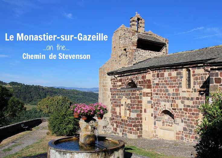
The pamphlet also had a lot of useful maps-on-paper. That’s why I kept it handy in the right side-pocket of my tan Magellan quick-dry, water-repellent pants. And which finally brings us to Stevenson’s book, and some differences between his hike and ours. For one thing, while we started in Le Puy, he started in Le Monastier-sur-Gazelle. (Where he got his donkey “Modestine,” mostly because his 6×6-foot sleeping bag was too big for him to carry on his own.)
On the other hand, his first chapter in the book is titled “Velay,” which needs some explaining. It doesn’t refer to the town of Le Puy. As Stevenson used the term, Velay referred to the larger “historical area of France situated in the east Haute-Loire département and southeast of Massif Central. No longer a separate district, it now forms part of the department of Haute-Loire.”
In other words, Velay used to be an autonomous administrative district, but after the French Revolution it got “disassembled,” blended into a whole ‘nother French department. So as fully translated into English (and maybe “legalese’) the term Le Puy en Velay would translate to something like “the town near that volcanic hill in the district of Velay.”
But back to Monistair: Stevenson described the town as being in a “pleasant highland valley fifteen miles from Le Puy.” (Tom’s calculations had it as 12 miles.) Stevenson said the town was notable for “the making of lace, for drunkenness, for freedom of language, and for unparalelled political dissension.” I found it notable mostly for its “iffy” WiFi and the fact that we suffered a “dry” Sunday. (“No beer!” So much for Stevenson’s “drunkenness” problem.)
That is, we started hiking on the 17th – a Sunday – and covered the 12 miles to Le Monastier. (Verified by Carol’s step-counter.) We ended up at a “Files de chamber,” at 25 Rue St. Pierre, and I remember the town – “even to this day” – because by the time we got there Le Monastier was closed down. Or “closed up tight.” After dinner Tom and I went out to find someplace to get a beer, but couldn’t find a single place open. Which is rare on a Camino, but there was still that “warm bed and hot shower” part of the equation. Besides, I figured the discipline was good for my soul. Then too there was no internet. Which explains my Facebook note-entry at the end of the day on September 18, after we had hiked the 11.5 miles to Bargettes:
Sorry about the two-day incommunicado, but WiFi here in France is iffy at best. And we now have two hiking days under our belts, with me only developing one big blister yesterday, on the ball of my left foot. Thanks in large part to hiking over slippery-rock trails… And today, tip-toeing – not through tulips – but trying to NOT step down hard on that one blister-foot.
I also noted – not the last time – that the scenery we saw was spectacular, “full of awesome vistas, but you paid a price to see them.” I also remember – about the place we stayed that night – that the “lady at the mom and pop b&b insisted we leave our shoes and packs downstairs.” That meant we could only take “essentials” up to our second-floor rooms. (“But if everything you own is in a 20-pound pack, how many non-essentials are there?”) On the other hand, the evening dinner that “mom and pop” served up was delicious. (Even without beer.)
But I’m getting ahead of myself. To be a good travel writer “a la Hemingway” I need to add some vivid descriptions of that first day’s hike, and that brings up a problem. Looking back on the hike I didn’t take as many descriptive notes as I should have. But I did take lots of pictures, using a system I’ll describe in the next post. (Another thing Hemingway didn’t have, besides Google Maps; a tablet to take pictures and post them back home.) I’m hoping those photos can jog my memory enough to paint some vivid word pictures, so here goes.
But first, here’s what some other hikers have said. One said the first day’s hike features a “short and relatively steep descent into the Upper Loire Valley,” then through “charming hamlets and across volcanic plateau.” Another said you hike through forests and farmlands, the “quintessential rural France, dotted with small towns and farming communities.”
I took six pictures of that first day’s hike. The first one shows a path strewn with large rocks, intermingled with fallen leaves, which could – I could foresee – turn very slippery if we got any rain. There’s a waist-high rock wall to the left, and more rocks – “unorganized” and tumbledown – on the right. Trees shade each side. The climb is steep. The second shows the trail narrowing, with a few less rocks but crowded in on each side with thick underbrush, along with thick trees and a small patch of blue sky ahead. Much the same in the third picture, but much steeper and with bigger rocks clogging the trail, which is a bit wider.
In the fourth picture we finally hit a wide smooth trail, with more blue sky and taller trees. Much the same in the fifth photo; though the trail is not as wide, the trees seem taller and there’s less blue sky. Finally, the last picture shows a return to a steeper, boulder-strewn path that looks – and often was – slick and slippery. And quite a struggle to clamber up.
Which seemed to set the pattern for the whole hike. At the end of each day, when you were most tired, footsore, and thinking “where the hell is this place…” That’s when we seemed to hit the rockiest, steepest, slipperiest part of the path. But you kept on, knowing that fairly soon you should find that warm bed, hot shower and cold beer. (Unless you hit Monistair on a Sunday.)
* * * *
So, that first day’s hike was pretty much a shakedown cruise, both in terms of the hike itself and in what I’ve been able to write about it. (That is, a preliminary activity that serves as a test or trial for how something will work on a larger scale or under more rigorous conditions.) But at least I and my two hiking companions are finally on the Trail, and on the way to more adventures. (And with my first-day blister out of the way.) Coming up, an “interesting” lunch in Goudet, then on to Bargettes and in time, “camping above the clouds.” Next time…
* * * *

* * * *
The upper image is courtesy of Le Monastier-sur-Gazeille (Chemin de Stevenson) – I Love Walking in France. See also Le Monastier-sur-Gazeille – Wikipedia.
More about the district of Velay, from Wikipedia:
At the beginning of the 16th century, Velay was wealthy, but the religious wars ruined the country. Le Puy was ardently catholic but the extreme south east of Velay was deeply Protestant. It is still nowadays the most Protestant area of France… Velay ceased to exist after the French Revolution… The department of Haute-Loire was created from the former county of Velay, on top of it a portion of Auvergne, Gévaudan and Vivarais are added.
According to Departments of France – Wikipedia, a “department” is an administrative district, of which there are 96 in metropolitan France, “further subdivided into 333 arrondissements.”
Re: Shakedown cruise. Also called a sea trial, which according to Wikipedia is a testing phase that can last “from a few hours to many days.” Which explains that first-day blister.
Sources detailing the hike include Robert Louis Stevenson Trail GR70 – The Enlightened Traveller®. It said you start from Le Puy “with a short and relatively steep descent into the Upper Loire Valley. Then climb over 400 metres, through charming hamlets and across volcanic plateau before arriving at Stevenson’s first overnight stop,” Le Bouchet, not Le Monistair. Another, Walking the GR70 Chemin de Stevenson – I Love Walking In France, said this:
For the first few days, the GR 70 passes through forests and farmlands and the countryside appears deceptively gentle (although your leg muscles will likely disagree!). This is quintessential rural France, dotted with small towns and farming communities. The clanging of cow bells heralds the beginning and end of each working day and cattle choke the quiet country roads as they make their way to and from the milking sheds. Life here feels productive and purposeful—and relaxed!
I’ll be referring to those two sites in later posts, as I did before and during the hike.
The lower image is courtesy of Credencial Stamped Camino – Image Results. See also The credential and Compostela – Way of Saint James in Galicia.
* * * *
Re: The Israelite. Harry Golden grew up in the Jewish ghetto of New York City, but eventually moved to Charlotte, North Carolina. Thus the “Carolina Israelite.” I on the other hand am a “classic 72-year-old “WASP” – White Anglo-Saxon Protestant – and live in north Georgia. Thus the “Georgia Wasp.”
Anyway, in North Carolina Harry wrote and published the “israelite” from the 1940s through the 1960s. He was a “cigar-smoking, bourbon-loving raconteur.” (He told good stories.) That also means if he was around today, the “Israelite would be done as a blog.” But what made Harry special was his positive outlook on life. As he got older but didn’t turn sour, like many do today. He still got a kick out of life. For more on the blog-name connection, see “Wasp” and/or The blog.
* * * *