
* * * *
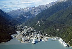 Last Tuesday – July 26 – my brother and I started the long drive north, from Utah to Skagway, Alaska. (At left.)
From there our plan was to spend four days hiking the Chilkoot Trail. (The “meanest 33 miles in history.”)
In fact, the Chilkoot is so mean that we had to invite my nephew – my brother’s son, just out of the Army – to go along with us. (Just in case one or both old geezers sprained or broke something…)
Now, about “all those furriners…”
That’s pretty much the way I felt several times over the last few days. (After we crossed over into Canada, on Wednesday, July 27.) But it got especially bad at the free breakfast we had at the Super 8 in Fort Nelson, BC, on Friday morning, July 29.
I’ll have more on that later. But first, some highlights from our trip north.
The first day out we made Great Falls, Montana. We drove 560 miles, starting around 9:00 a.m. My photo at right shows the sky to the east, just as we got to the Great Falls exit.
That means we had 120 miles to go, to get the Canadian border. (Unless they’ve built a wall or something.) And driving through eastern Idaho and Montana was a good reminder of how HUUUUGE this country is, and especially the west.

It took about 30 minutes to go through Canadian customs, where Interstate 15 becomes Canada Highway 4. That’s where we had to “Arretez-vous, ici.” (“Stop here.”)
Which brings up some of the anomalies of traveling in Canada.
For one thing, aside from speaking French, Canada uses kilometers instead of miles. So when the speed-limit sign says “Maximum 110,” you have to calculate kilometers to miles. (Divide the number in half, then add 10 percent.) So using that method – half of 110 is 55, plus 11 – and you figure out that means about 65 mph on your dashboard.
And that when the speed sign says “40,” that means you have to slow down about 25 mph.
Then too, at first blush the gas prices seemed unbelievable. For example, we saw signs in Alberta that said “96.9.” Unfortunately, that was the price for a liter, or one-fourth of a gallon. So multiply that by 4 and you get gas at $3.87. (In British Columbia we paid over $5.00 a gallon.)
Another thing, driving through Alberta. We saw acres and acres of fields like this:

At first I thought the yellow-flowered crop-fields might be “golden rod,” but it turns out they were fields of Canola. (See “A Canadian success story.”)
Then too, they have a weird system for Americans to pay for gas up here. You have to swipe your credit card, then go in to the office and sign something. It sounds simple but in practice it can be easy to forget. Which explains why my brother Tom drove off from the Shell station in Airdrie. We ended up still making good time, despite having to backtrack a bit. (And make a belated payment for the gas, on pain of seeing “rollers” in our rear-view mirror.)
That night we made it to Drayton Valley, Alberta. (West and a tad-bit south of Edmonton. And Calgary was HUGE to pass through!) The next night – Thursday – we made it to Fort Nelson, British Columbia. In America-talk, Fort Nelson runs from Mile-marker 301 to 308.
 And that would be on the famed Alaska Highway, which officially starts in Dawson Creek, British Columbia. (As shown at left.) We passed through Dawson Creek about 3:00 in the afternoon, on the way to Fort Nelson. And at the border of British Columbia, that 3:00 became 2:00.
(Thanks to the change-over to Pacific Time.)
The next day – Friday, July 29 – we made it Whitehorse, Yukon Territory. That happened despite our worst expectations, and a slew of stoppages for highway construction along the way.
This was after three straight days of 12-or-more-hours-of-driving. I got plenty of pictures, but for some reason they don’t transmogrify from my cell phone to my computer, the way they do back in America. And in fact there was no cell-phone service at all. Once you hit the Canadian border, you can forget about texting the folks back home.
And I found out that my American mobile hotspot doesn’t work in Canada either. (Which may explain why the cell-phone pictures don’t transfer.) I hoped that once we got to Skagway, in Alaska – which is technically in the U.S. – those problems would go away, but they didn’t. Still no cell phone service, and still no mobile hotspot.
 So anyway, we hit the city limits of Whitehorse at 7:00 p.m. (Pacific Time, or 10:00 p.m. ATL Time.) Saturday morning we checked out the Yukon River for the canoe part of this expedition. (That is one FAST current, estimated at about 7 miles per hour.) Then we drove to Skagway and got there early Saturday afternoon. (To prep for the hike on the Chilkoot Trail, as seen at right, in winter.)
However, there was yet another mix-up about what the actual time was when we got here. When we crossed into British Columbia – Thursday – I started gearing up to Pacific Time. (Three hours earlier than ATL time.) But when we got to a “necessary” store in Skagway, the sign said, “Be back at 1:45,” and it was well past that. That’s when I learned that Skagway is on “Alaska Time.” Alaska Time is one hour earlier than Pacific Time, which meant that when it 3:10 when we arrived in Skagway, it was 7:10 back in Atlanta.
One final note: We DID get to watch the 13-minute video on what to do when you meet up with a bear. That was for the benefit of those hardy folk planning to hike the Chilkoot Trail. My take on the video: “Be sure and get behind the OTHER two guys in your hiking party!”
As noted before, stay tuned for “further bulletins as events warrant!”
I’ll let you know how the hike on the Chilkoot Trail turns out…
* * * *

* * * *
The upper image is courtesy of Willie & Joe: Summary-1 – amyatishkin. (And of course,Bill Mauldin.)
The lower image is courtesy Calvin and Hobbes Comic Strip, October 25, 1986.