* * * *

* * * *
Welcome to the “Georgia Wasp…”
This blog is modeled on the Carolina Israelite. That was an old-time newspaper – more like a personal newsletter – written and published by Harry Golden. Back in the 1950s, people called Harry a “voice of sanity amid the braying of jackals.” (For his work on the Israelite.)
That’s now my goal as well. To be a “voice of sanity amid the braying of jackals.”
For more on the blog-name connection, see the notes below.
In the meantime:
July 20, 2026 – The last post got our May ’26 driving trip in Ireland from Cork to the Drombeg stone circle, 41 miles south and hard by the coast. From there it was a bit over two miles to Glandore Inn for lunch, a place that Brian (from Cork) suggested. And about learning how to “adapt, improvise and overcome” is essential to a successful travel-trip, especially renting a car in Ireland. (With it’s “drive on the left side, not the right” and those narrow, twisting roads too often lined by thick stone walls six inches from the side of your rental car.)
Glandore is said to be “one of the most beautiful and most scenic villages in West Cork, positioned on rising ground overlooking Glandore Bay.” And the Glandore Inn provides “commanding views across the bay and the islands of Adam and Eve guarding the entrance to Glandore Bay and the harbour.” (As for those Adam and Eve rocks in the bay, the sailing directions are “to avoid Adam and hug Eve.”) For lunch we shared a “great veggie soup of the day with dark bread while sitting outside viewing the bay.” And as we were to learn, sunny days were rare that May.

From there – on Tuesday, May 12 – we drove 60 miles to Dunboy Castle, much of it along Bantry Bay in southwest Ireland. Built in the 16th century, it’s opposite Bere Island to the east. (Also called Bear Island, though officially it’s An tOileán Mór, or “the big island.”) The castle served as stronghold of the O’Sullivan family, “a prominent Gaelic clan.” (And my partner’s paternal grandmother was a direct descendant.) Strategically located on a rocky outcrop on Beara Peninsula overlooking the sea, it was destroyed in 1652 “during the Cromwellian conquest of Ireland.” (Memorialized by the plaque at left.)
That is, in the summer of 1602 it was the scene of the noted Siege of Dunboy:
Elizabeth I had sent a 5000-strong army under the command of Sir George Carew to suppress the insurgents. Even with its small garrison of 143 men, Dunboy Castle was thought to be impregnable but following a fierce artillery bombardment the walls were smashed and after some desperate hand-to-hand fighting amid the rubble the defenders were finally overcome. The 58 survivors of the two-week siege were executed in the nearby market square.
Today it’s in ruins – “reflecting the turbulent past of Ireland” – but still a popular tourist attraction offering scenic views. I don’t remember seeing any other tourists that day, possibly because the footing was shaky, especially for my partner, still nursing a tender knee. Still, the sunny afternoon was perfect, delightfully cool but not cold, and we got lots of good pictures.
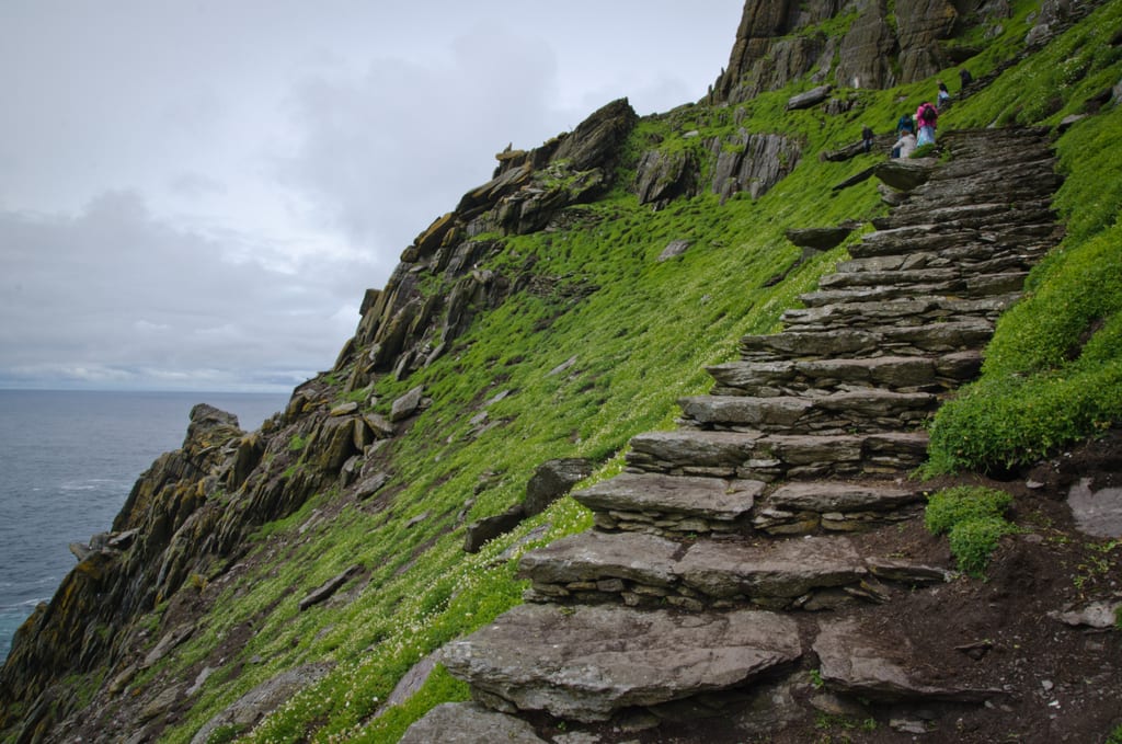
In the meantime, we kept watching the weather forecasts. The next morning, May 13, I was scheduled to catch the early boat in Portmagee, and from there I’d ride the choppy waters in a small boat, seven miles out into the Atlantic, to Skellig Michael, “a rocky island off the coast of County Kerry, Ireland, with a Gaelic monastery and a World Heritage Site.” Once there, I could climb to the top of the peak in a hike that can only be described as “arduous:”
First off, “600 steps to climb, most of them jagged slabs of rock.” This guy proceeded “at a snail’s pace, keeping my eye on every step.” And places to stop and rest were few and far between: “At times there was literally nowhere to stop but the steps themselves, as you’d pitch over the side of a cliff.” It’s not a place for people with mobility difficulties, or kids; “It’s just too easy to fall off the path.” (There is a helicopter pad on the island, “just in case.”) You bring your own food and plenty of water. And there are no toilets on the island, so take care of that on the boat ride out?
(That’s from last April 14’s A preview of Ireland – 2026.) The big problem? Getting there.
The dock on the island is very small, as is the boat taking you out there. And being seven miles out, the swells of the Atlantic can toss such a small boat like a cork, so the general rule is “no go if the wind goes above 20 miles an hour.” The forecast that next day? Winds averaging 28 miles an hour, and gusting even higher. But we had to wait for the official word from the tour company to find out for sure. (And get the 100-plus-dollars-or-pounds refund.)
The other problem? If the trip was on we’d have to leave our lodging at 8:00 in the morning, meaning we’d have to get up way earlier than that. (And hope for no bad traffic.) And speaking of lodging, it was 60 miles from Dunboy Castle to “Haven Suites Killarney Self Catering.”
In Killarney’s center, these self-catering apartments feature a welcome pack on arrival and scenic mountain and cathedral views. With free private parking and free WiFi, they are just 1.2 mi from the Lakes of Killarney. Each lounge area in Haven Suites – Killarney Self Catering apartments features a balcony and a TV/DVD player. A fully equipped kitchen is offered in every apartment, including an oven and microwave, a fridge, toaster and kitchen utensils.
So we kept checking the forecast, and meanwhile, driving toward Killarney “there was a minor incident.” I was driving, on the left side of the road. The landscape was sunny but sere, as in dried up or withered, with small rolling hills the color of wheat grass. It was all very enchanting, in a haunting Irish way, then came the incident. The road to the left was lined with a shallow gulley, and in my reverie my mind wandered just a bit. The wheels went off the road, just a bit, but enough to rattle me considerably, trying to get the car back under control.
(“A lesson for all you young kids out there!”)
From there my partner graciously took over the driving duties and we got to Killarney without further ado. We stopped briefly at Tesco in town, then found the apartment “great.” But we were tired from the day’s exertions, so I went out, walking, to a nearby pub for takeout fish & chip. (With a pint while waiting to settle my nerves.) And when I got back to the apartment and checked my email, there it was. The cruise out to Skellig Michael was officially cancelled. That meant we could sleep in a bit and wake up refreshed, ready for further adventures.
In the meantime, and about that trip out to Skellig Michael – “Wait till next year!”
* * * *

* * * *
The upper image is courtesy of Dunboy Castle – Wikipedia, along with the plaque photo below it. Caption: “Plaque on castle wall. Translation from Irish: ‘In memory of the heroes who fell in Dunboy on behalf of country and faith in June 1602. May their souls rest in peace.'”
See wait till next year — Baseball Dictionary – Baseball Almanac: “The plaintive mantra of fans whose team has once again fallen short of expectations; a baseball euphemism for a season gone awry.” Also Wait Till Next Year by Doris Kearns Goodwin | Goodreads, and Wait ‘Til Next Year: The Fan Bases That Never Catch a Break: “For fans of certain MLB teams … tested through generations of near-misses, epic collapses, and perpetual rebuilding. Here are the 13 MLB fan bases that have endured the most emotional roller-coasters, empty Octobers, and ‘wait till next year’ mantras.”
The lower image is courtesy of Skellig Michael – Wikipedia. Caption: “Path to Christ’s Saddle.”
* * * *
Re: The Israelite. Harry Golden grew up in the Jewish ghetto of New York City, but eventually moved to Charlotte, North Carolina. Thus the “Carolina Israelite.” I on the other hand am a “classic 74-year-old “WASP” – White Anglo-Saxon Protestant – and live in north Georgia. Thus the “Georgia Wasp.”
Anyway, in North Carolina Harry wrote and published the “israelite” from the 1940s through the 1960s. He was a “cigar-smoking, bourbon-loving raconteur.” (He told good stories.) That also means if he was around today, the “Israelite would be done as a blog.” But what made Harry special was his positive outlook on life. As he got older but didn’t turn sour, like many do today. He still got a kick out of life. For more on the blog-name connection, see “Wasp” and/or The blog.
* * * *